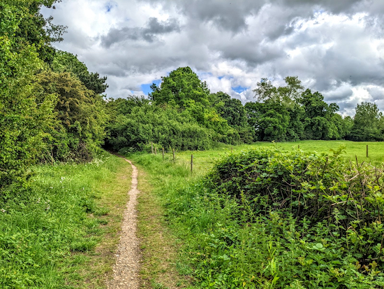
Site Information

Welcome to Hertfordshire Walker

CPRE Hertfordshire double award winner 2022

Showing posts with label Cowper Arms - Cole Green. Show all posts

Walk 175: Hertford to Cole Green

5.5 miles (8.8 km) with 89m of total ascent


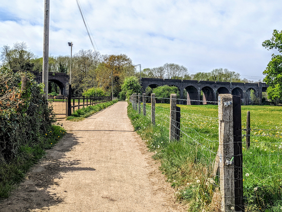
The Cole Green Way
The Cole Green Way
We mapped this route following a request on Twitter for a walk that is buggy friendly and involves a pub. The person who contacted us lives in Hertford. So we just put this walk together for any buggy pushers who live in Hertford and want a flat route with the option of refreshments at the start, middle point, and end.

The walk can be enjoyed one-way if you can get someone to pick you up at The Cowper Arms (2.6 miles), or, if you have the stamina, turn back from the pub and return the same way (5.5 miles). There is a pub, The Black Horse (location - https://w3w.co/names.muddy.successes) near the start of the walk. It has a lovely beer garden at the back and is a CAMRA freehouse.

The walk is mainly along the Cole Green Way, which follows what was the route of the old Hertford to Welwyn Junction Line. It's also part of the Lea Valley Walk. Here is the request we received on the Hertfordshire Walker Twitter feed.

Twitter request for a buggy friendly walk with a pub at the end
So this is what we produced.

Directions


Map for Walk 175: Hertford to Cole Green
(click here or on the map for larger version)
Created on Map Hub by Hertfordshire Walker
Elements © Thunderforest © OpenStreetMap contributors

There is an interactive map below these directions
Those with GPS devices can download GPX or KML files for this walk. We've added What3Words location references for those who use that system. If you print these walks you might want to use the green PrintFriendly icon at the bottom of these directions to delete elements such as photographs.

For those driving to the start of the walk, we saw several parking places near the the junction mentioned in point 2 below (location - https://w3w.co/venue.curiosity.loss) We didn't park there and we didn't check any parking restrictions.

The byway heading SW off West Street, Hertford
1: The route starts on West Street in Hertford, which is accessible from the town centre via a pedestrian crossing with traffic light control over the A414. Walk WSW along West Street passing the Black Horse pub freehouse on the left which has an lovely beer garden at the back and serves excellent real ale (location - https://w3w.co/names.muddy.successes).

Continue heading SW for 430m to reach a byway on the right (location - https://w3w.co/prop.gives.deaf). This is Hertford BOAT 54 (byway open to all traffic).

Hertford BOAT 54 heading SW towards the viaduct
2: Turn right on Hertford BOAT 54 then head SW and W for 400m, crossing the River Lea via a bridge (location - https://w3w.co/filer.pulled.vivid) then passing Hertford Town Football Club on the right (location - https://w3w.co/hats.truth.ships) and continuing until you reach a railway viaduct (location - https://w3w.co/decay.search.bring).

Once you reach the Cole Green Way follow it SW
3: Go under the viaduct then continue heading SW, now on Hertford footpath 55, for 80m until you reach the Cole Green Way (location - https://w3w.co/text.shells.lonely). Turn left on the Cole Green Way then follow it SW and W for 2.1 miles (3.4 km) until you reach the remains of the old Cole Green Station (location - https://w3w.co/sports.senior.chins).

Continue heading WSW along the Cole Green Way
As you head along the Cole Green Way the former railway branch line will cross a number of lanes including St Mary's Lane (location - https://w3w.co/divisions.backs.emerge), Staines Green (location - https://w3w.co/raft.digits.leaves), and Birch Green at its junction with Chapel Lane (location - https://w3w.co/critic.teams.dairy). You will also notice several footpaths on the right and left; ignore them all.

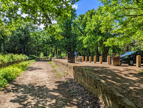
The approach to Cole Green station with the platform on the right
4: Leave the Cole Green Way by by turning right and climbing up the ramp to reach what was the platform at Cole Green Station then turn left when you reach the car park and head W for 120m until you reach Station Road (location - https://w3w.co/medium.farm.ozone). Turn right on Station Road and The Cowper Arms is on your right (location - https://w3w.co/rarely.cities.bronze).

For those returning to Hertford just follow the route in reverse. 

Interactive map


Walk 149: Cole Green Way Loop

5.6 miles (9km) with 93m of total ascent


Hertingfordbury footpath 1 between points 5 & 6
This walk includes elements from two earlier walks in this series that both share a 2-mile stretch of The Cole Green Way, a former branch line between Hertford and Welwyn Garden City which is now a long-distance recreational route. The other walks are Walk 35: Letty Green Loop (3 miles) and Walk 93: Grotto Wood Loop (4.3 miles). This walk, which is the longest of the three, follows a footpath and part of a bridleway which are not featured in the other walks and which were both ablaze with wild flowers when we tested the route in July.

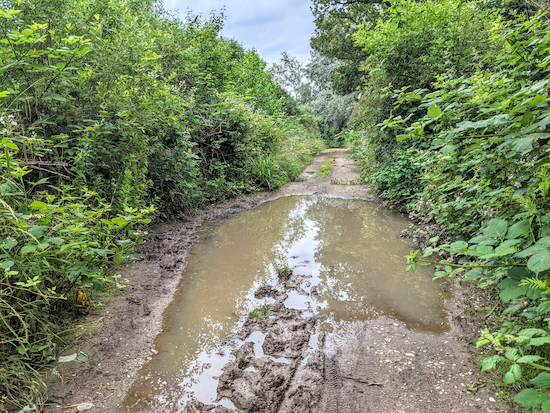
There is a section of lane walking, but the lane is quiet with plenty of space to stand to the side if vehicles approach. There is also one spot on one of the bridleways which was waterlogged when we did the walk, but we managed to get round the short stretch without a problem. Waterproof footwear is recommended. In the summer, some of the footpaths, particularly between points 5 and 6, can been a bit overgrown, so you might want to pick up a stick to push back any nettles.

Directions


Map for Walk 149: Cole Green Way Loop Created on Map Hub by Hertfordshire Walker Elements © Thunderforest © OpenStreetMap contributors There is an interactive map below the directions
Map for Walk 149: Cole Green Way Loop
Created on Map Hub by Hertfordshire Walker
Elements © Thunderforest © OpenStreetMap contributors

There is an interactive map below the directions
Those with GPS devices can download GPX or KML files for this walk. We've added What3Words location references for those who use that system. If you print these walks you might want to use the green PrintFriendly icon at the bottom of these directions to delete elements such as photographs.

Park in the small car park at the site of the former Cole Green Station off Station Road south of Cole Green (location - https://w3w.co/debate.gladiators.atomic).

1: Standing on the former station platform and facing what would have been the track, turn right and walk along the platform to the western end then go down the ramp to reach The Cole Green Way (location - https://w3w.co/fear.axed.loft).

Head W from the platform at the former Cole Green station
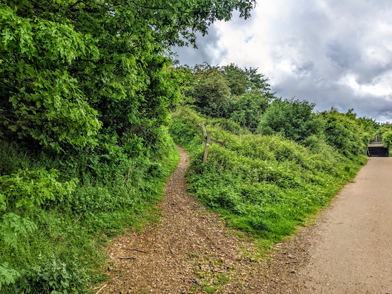
2: Join The Cole Green Way and head W for 890m until you reach a track on your left heading uphill into woodland. This track is 40m before a junction in the track and a tunnel under the A414 (location - https://w3w.co/drain.harsh.woof), see image below.

Take the path on the left and head SW
Follow this footpath SW through woodland for 160m until you reach a junction (location - https://w3w.co/aims.stews.trunk). At the junction turn left on Hertingfordbury BOAT (byway open to all traffic) 22 (which is also known as Deadfield Lane). Head ESE then ENE for 840m until you reach Letty Green (location - https://w3w.co/change.bunks.raves).

Hertingfordbury BOAT 22 heading ESE
3: Turn right on Letty Green and head SSE for 90m looking out for a byway on the left (location - https://w3w.co/fend.income.held). This is Hertingfordbury restricted byway 20. Follow this byway for 260m, first ESE then E until you reach Woolmers Lane (location - https://w3w.co/dizzy.exit.cards).

The start of Hertingfordbury restricted byway 20 off Letty Green
4: Turn right when you reach the lane and head SSE for 60m then follow the lane as it bends left and heads SE then ENE for 820m until you reach East End Green (location - https://w3w.co/lifted.clever.novel).

5: Turn right at East End Green and head S looking out for Hertingfordbury footpath 1 which cuts between the houses (location - https://w3w.co/muddy.insect.judge), see image below.

Hertingfordbury footpath 1 goes to the left of the house on the right
Follow Hertingfordbury footpath 1 as it heads SSW then SSE for 800m until you reach a permissive footpath on the left just before wooden steps (location - https://w3w.co/takes.regard.radar).
* This permissive path has been put in place to guide walkers away from the official public right of way which goes through a working quarry. We chose to ignore the permissive path because it was heavily overgrown with brambles and nettles. But if you want to take this permissive path turn left and rejoin the route 70m north of point 7 below (location - https://w3w.co/landed.grades.wages).
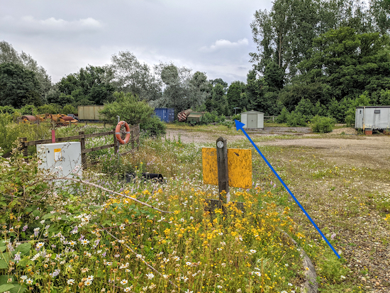
6: Continue heading SSE for 260m crossing a quarry track and eventually reaching a T-junction (location - https://w3w.co/fool.herb.trunk).

Hertingfordbury footpath 1 crossing the quarry

Cross the quarry track in the direction of the blue arrow

Hertingfordbury bridleway 2 after the quarry where you turn left
7: Turn left on Hertingfordbury bridleway 2 and head NE. After 120m we came across a small waterlogged section of the bridleway (location - https://w3w.co/trades.luck.rots), see image below.

The puddle along Hertingfordbury bridleway 2
We were able to proceed by walking to the left of the water and holding onto a wooden fence for support. Continue for 630m until the bridleway bends to the left and then turns right (location - https://w3w.co/finger.unwanted.each).
* At this point you could take a short detour to explore Grotto Wood which is a Baroque Garden listed by Historic England (location - https://w3w.co/struck.record.issue). The wood is 140m NW along Hertingfordbury footpath 3. If you do explore Grotto Wood take a stick to push back the nettles and brambles along the path.
8: If you don't take the detour, turn right, still on Hertingfordbury bridleway 2 and head NE for 900m at which point the bridleway becomes Hertford bridleway 57 and continues heading NE for 350m to St Mary's Lane (location - https://w3w.co/copy.spring.pass).

Continue heading NE on Hertingfordbury bridleway 2 - point 8
9: Turn left on St Mary's Lane and head N for 150m until you reach a track on the right just before a railway bridge (location - https://w3w.co/task.verge.values). Turn right before the bridge and take the track on the left up the embankment of the old branch line leading to The Cole Green Way (location - https://w3w.co/manage.couches.credit), see image below.

Take the track up the embankment to join The Cole Green Way
10: Turn left on The Cole Green Way and head SW then WSW for 1.3km until the track crosses a lane called Staines Green (location - https://w3w.co/raft.digits.leaves).

The Cole Green Way heading W
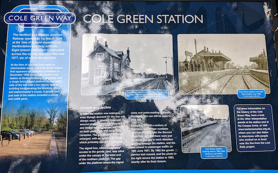
11: Cross Staines Green and rejoin The Cole Green Way heading W for 1.4km back to the start point. When you return to the starting point you might want to reads the information boards alongside the track beneath the platform. Sadly, one of them has been vandalised. Pity.

The approach to Cole Green station with the platform on the right

One of the signs at Cole Green station
 
One of the information boards at Cole Green Station
 

If you want refreshments after your walk The Cowper Arms is a 150m W of the car park.

Interactive map


Walk 93: Grotto Wood Loop

4.3 miles (6.85 km) with 71m total ascent


The Cole Green Way - route of a disused railway track Image by Hertfordshire Walker released via Creative Commons BY-NC-SA 4.0
The Cole Green Way - route of a disused railway track
This is an easy walk along the disused Hertford to Welwyn Junction railway track and through farmland. You pass a lake surrounded by rushes - birdwatchers should take their binoculars. And you can explore the Historic England scheduled monument, the Baroque gardens at Grotto Wood. There are some muddy stretches, so good footwear and a walking stick are recommended.

Directions


Map for Walk 93: Grotto Wood Loop Created on Map Hub by Hertfordshire Walker Elements © Thunderforest © OpenStreetMap contributors See the interactive map below the directions for KML and GPX details
Map for Walk 93: Grotto Wood Loop
Created on Map Hub by Hertfordshire Walker
Elements © Thunderforest © OpenStreetMap contributors

There is an interactive map below the directions
Those with GPS devices can download GPX or KML files for this walk. We've added What3Words location references for those who use that system. If you print these walks you might want to use the green PrintFriendly icon at the bottom of these directions to delete elements such as photographs.

Park in the public car park to the south of the Cowper Arms pub and restaurant in Cole Green (location - https://w3w.co/debate.gladiators.atomic). The car park is alongside what was the station platform at Cole Green station.

1: Head E along the route of the old railway track for 1km (see image at the top of these directions). Along the way you will cross Birch Green close to the junction with Chapel Lane (location - https://w3w.co/email.plus.pinks). Continue heading E until you come to a footpath crossing the track (location - https://w3w.co/fast.dash.pumps), see image below. This is Hertingfordbury footpath 4.

The footpath leaving the Cole Green Way, see point 2 below Image by Hertfordshire Walker released via Creative Commons BY-NC-SA 4.0
The footpath leaving the Cole Green Way
2: Turn right on the footpath and leave the disused railway, dropping down to a footbridge over a brook (see image below).

The footbridge across the stream mentioned below Image by Hertfordshire Walker released via Creative Commons BY-NC-SA 4.0
The footbridge across the stream mentioned above
After crossing the footbridge head straight SE and slightly uphill for 170m with the fence on your left and the field on your right. Follow this path until you meet a lane called Staines Green (location - https://w3w.co/point.filer.forces). Turn right and head SSE for 40m until you reach a track going off to your left (location - https://w3w.co/regard.fats.adjust), see image below.

Hertingfordbury restricted bridleway 19 Image by Hertfordshire Walker released via Creative Commons BY-NC-SA 4.0
Hertingfordbury restricted bridleway 19
3: Take this track, Hertingfordbury restricted bridleway 19, and head SSE for 80m until you see a gate and marker post on your left (location - https://w3w.co/wonderfully.perky.splash). This is Hertingfordbury footpath 3.
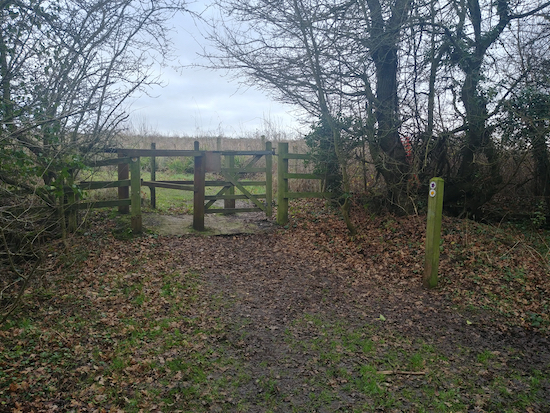
The gate and footpath marker mentioned in point 4 below  Image by Hertfordshire Walker released via Creative Commons BY-NC-SA 4.0
The gate and footpath marker mentioned in point 4
4: Go through the gate, turn left and follow this footpath as it climbs first NE for 90m then swings SE and continues for 500m past some disused workings which now form a lake (location - https://w3w.co/prove.front.during) surrounded by rushes and frequented by birds. Ornithologists might want to pause at this spot (see image below).

The lake mentioned in point 4 above Image by Hertfordshire Walker released via Creative Commons BY-NC-SA 4.0
The lake mentioned in point 4
5: After passing the lake continue heading SSE, still on Hertingfordbury footpath 3 for 150m with Grotto Wood on your right. At the end of Grotto Wood there is an entrance (location - https://w3w.co/shut.wink.skip). It's free of charge to explore the 1.75 hectares containing “substantial earthworks”. The following is from the Historic England site:
“The baroque garden in Grotto Wood is a compact and well-preserved example of this monument class, uncommon in that it was independent of its parent residence. The earthworks, undisturbed by subsequent redesign or changes in land use, will retain buried evidence relating to the former garden buildings, the water management system and the planting scheme, and may provide additional information concerning its period of construction and use. Contemporary documents confirm the functions of the various earthwork features and give a clear and vivid impression of the former structures and ornamentation of the established garden, and chart its abandonment and subsequent descent into obscurity. This garden is unusual in that it belonged to members of a disadvantaged religious minority of the merchant class rather than the landed gentry. As such it provides important contrasts with bigger, more famous gardens and allows significant insights into different levels of 18th century society.”
The sign at the gate to Grotto Wood explains what visitors are likely to see when visiting (see image below).

The sign at the entrance to Grotto Wood Image by Hertfordshire Walker released via Creative Commons BY-NC-SA 4.0
The sign at the entrance to Grotto Wood
After leaving Grotto Wood continue heading SE for 120m until you reach a gate and a footpath junction (location - https://w3w.co/finger.unwanted.each), see image below.

The footpath junction mentioned above - here you turn left Image by Hertfordshire Walker released via Creative Commons BY-NC-SA 4.0
The footpath junction mentioned above - here you turn left
6: Turn left and head NE along Hertingfordbury bridleway 2 for 1.25km until you reach St Mary’s Lane (location - https://w3w.co/bells.formed.sweep). This bridleway takes you through Southfield Wood where someone has created horse jumps to the left of the path. Because this is a bridleway, some parts can be muddy, particularly towards the junction with St Mary’s Lane.

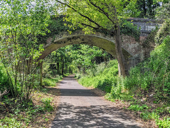
7: Turn left on St Mary’s Lane and head NNE for 150m until you spot an old railway bridge (see image below). Here you turn right (location - https://w3w.co/sums.fried.gears) on Hertford BOAT 56 (byway open to all traffic) for 10m before taking the path on your left (location - https://w3w.co/panels.fantastic.works).

The railway bridge across St Mary’s Lane mentioned in point 7 above Image by Hertfordshire Walker released via Creative Commons BY-NC-SA 4.0
The railway bridge across St Mary’s Lane mentioned in point 7
This path leads to the disused railway and Cole Green Way (see image below).

8: Climb up to the track, turn left, and head WSW following the route of the former railway track.

The path leading back up to the Cole Green Way mentioned in point 8 above Image by Hertfordshire Walker released via Creative Commons BY-NC-SA 4.0
The path leading back up to the Cole Green Way mentioned in point 8
Continue for 1.4km crossing a lane called Staines Green (location - https://w3w.co/drums.sharp.lands) and continuing until you reach the footpath junction you encountered at point 2 above.

9: Turn right here on Hertingfordbury footpath 4 and head NW and uphill to the outskirts of Birch Green (location - https://w3w.co/ship.secure.shield). Continue straight between the houses, along Foxdells, turn right at Birch Green Lane, and then look out for a footpath sign on your left (location - https://w3w.co/give.guises.socket), see image below. This is Hertingfordbury footpath 7.

The footpath off Birch Green Lane mentioned in point 9 above Image by Hertfordshire Walker released via Creative Commons BY-NC-SA 4.0
The footpath off Birch Green Lane mentioned in point 9
10: Follow this footpath as it heads SW down to a stream (location - https://w3w.co/bits.fork.flank). This bit can be muddy after rain. We got really messy here. A stick would be handy because it’s on a slope and slippy.

11: Cross the stream and immediately turn right on the footpath that runs NW along the S side of the stream. This is Hertingfordbury footpath 8; another good spot for bird-watchers.

The path and bullrushes mentioned in point 11 above Image by Hertfordshire Walker released via Creative Commons BY-NC-SA 4.0
The path and bullrushes mentioned in point 11
12: Head NW then WNW along Hertingfordbury footpath 8 for 375m until you reach the point where a footpath crosses your way. Here you turn right to cross the stream (location - https://w3w.co/labs.bring.both), see image below. Once across the stream turn left and walk W and then SW on the N side of the stream for 450m, still on Hertingfordbury footpath 8, until you reach Station Road in Labby Green (location - https://w3w.co/cups.shots.statue).

The crossing over the stream mentioned in point 12 above Image by Hertfordshire Walker released via Creative Commons BY-NC-SA 4.0
The crossing over the stream mentioned in point 12
13: Turn left on Station Road, walk past the Cowper Arms (location - https://w3w.co/tunes.lows.broad), and then turn left along the track back to the car park.

Interactive map


Walk 35: Letty Green Loop

3 miles (4.8 km) with 27m total ascent


The Cole Green Way
The Cole Green Way
A short circular walk which starts along Cole Green Way, which is the route of the former Hertford to Luton and Dunstable branch line via Welwyn Junction. The walk starts and finishes at what was Cole Green Station and goes through woodland, along lanes and back following the route of the track to the car park. There is a pub, The Cowper Arms, close to the start/finish point.

Fly through preview of walk


If you want to check what sort of landscape this walk covers before setting off you can view a short 3D video of the route below. It's created using the free version of Relive.


Directions


Walk 35: Letty Green Loop
Click here or on map for larger version
Created on Map Hub by Hertfordshire Walker
Elements © Thunderforest © OpenStreetMap contributors

There is an interactive map embedded at the end of these directions
Those with GPS devices can download GPX or KML files for this walk. We've added What3Words location references for those who use that system. If you print these walks you might want to use the green PrintFriendly icon at the bottom of these directions to delete elements such as photographs.

Cole Green station platform at the start of the walk
1: Standing on the platform at the former Cole Green station (location - https://w3w.co/dots.chemistry.breath) and facing what was the track, turn right then head W for 880m along the route of the old railway until you reach a path on the left (location - https://w3w.co/drain.harsh.woof), see image below.

Turn left on the path then head SW
2: Turn left on the path, which, when we revisited this walk in May 2022, was becoming overgrown with nettles, then head SW for 170m to a junction with Hertingfordbury BOAT 22 (byway open to all traffic), also known as Deadfield Lane (location - https://w3w.co/reef.anyone.hotels).

The path between points 2 & 3 becoming overgrown with nettles
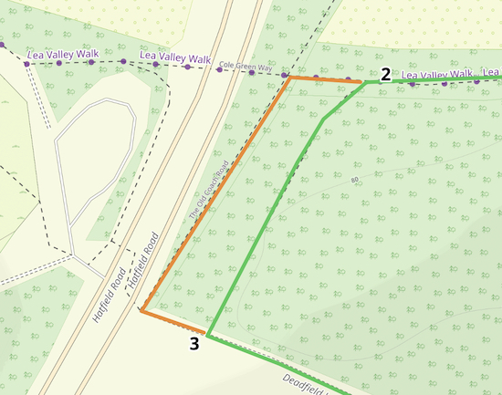
Note: If this path is overgrown with nettles there is a detour, see map below. The detour is in orange.

Detour in orange if path between 2 & 3 is overgrown
Created on Map Hub by Hertfordshire Walker
Elements © Thunderforest © OpenStreetMap contributors

Follow Deadfield Lane, Hertingfordbury BOAT 22, ESE then ENE
3: Turn left on Deadfield Lane, Hertingfordbury BOAT 22, then follow it heading ESE then ENE for 850m until you reach Letty Green (location - https://w3w.co/lined.chose.nights).

4: Turn right on Letty Green then head SSW for 110m until you reach a byway on the left (location - https://w3w.co/occurs.tame.secret).

Hertingfordbury restricted byway 20
5: Take this byway, Hertingfordbury restricted byway 20, then head E for 250m until you reach Woolmers Lane (location - https://w3w.co/drip.hungry.faster).

6: Turn right on Woolmers Lane then follow it SE for 50m where the lane bend left (location - https://w3w.co/mount.during.loser) at which point the lane is called Pipers End and continues heading ESE for 350m passing Chapel Lane on the left (location - https://w3w.co/shunts.memory.bucks). Continue heading along this lane first ESE then ENE and NE for 1.1km. This lane becomes East End Green then Staines Green before it finally reaches the track of the old railway, The Cole Green Way (location - https://w3w.co/broken.deck.glory).

Turn left and follow the Cole Green Way
7: Turn left when you reach the Cole Green Way then head W for 1.25km back to the starting point.

Interactive map
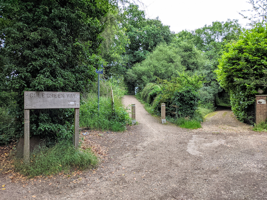


Facebook group rules

Facebook group rules
We have set 10 rules for our Hertfordshire Walker Facebook group which are designed to help keep the group focused on walking in the Hertfordshire countryside

Supported Charity: The Trussell Trust

Supported Charity: The Trussell Trust
Supporting those locked in poverty

Search This Site