Site Information

Welcome to Hertfordshire Walker

CPRE Hertfordshire double award winner 2022

Walk 101: Colney Heath Loop

2.4 miles (3.9 km) with 32m total ascent
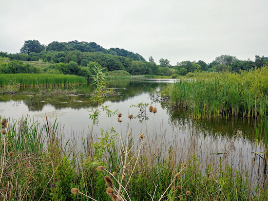

Willows Lakes
Willows Lakes
This is a short walk across Colney Heath, along the River Colne, and alongside Willows Lakes (renamed Albans Lakes in 2018), where anyone who enjoys bird-watching could be in for a treat depending on the season, particularly between points 5 and 6. There is free parking at the start and finish, and a pub, The Crooked Billet, in Colney Heath, a short diversion from the route. This walk is a shorter version of another walk on this site, Colney Heath South Loop.

Directions


Map for Walk 101: Colney Heath Loop Created on Map Hub by Hertfordshire Walker Elements © Thunderforest © OpenStreetMap contributors There is an interactive map below the directions
Map for Walk 101: Colney Heath Loop
Created on Map Hub by Hertfordshire Walker
Elements © Thunderforest © OpenStreetMap contributors

There is an interactive map below the directions
Those with GPS devices can download GPX or KML files for this walk. We've added What3Words location references for those who use that navigation system. If you print these walks you might want to use the green PrintFriendly icon at the bottom of these directions to delete elements you don't need.

Park along the track west of Coursers Road to the south of Colney Heath, (location - https://w3w.co/cabin.spoon.dozen). Please keep to the public rights of way on this walk. We have included a map at the foot of this page showing the public rights of way around Willows Lakes in green and the paths reserved for those fishing the lakes in red.

1: Take the footpath that leads across the heath but turn left after 15m on Colney Heath footpath 36, following it as it bends SW and then turns NW through the woods for 280m until you meet a footpath junction (location - https://w3w.co/baking.quick.jars). This is where Colney Heath footpath 36 heads SW across the field. You will return on this path, but for now, ignore it and continue NW through the woods for another 100m until you reach the open heath (location - https://w3w.co/agree.bricks.improving). You are now on Colney Heath footpath 35. Follow this path W for another 440m until you meet Church Lane (location - https://w3w.co/social.pose.awake).

2: Turn left on Church Lane for 20m before taking the footpath on your right (location - https://w3w.co/lazy.fines.offer). This is Ridge footpath 2, which passes a model railway on the left run by the North London Society of Model Engineers. This track is also the Watling Chase Timberland Trail. Follow the footpath SW for 550m until you reach a track (location - https://w3w.co/gent.adults.sums).

3: Cross the track and then cross a bridge over a conveyor belt (location - https://w3w.co/gear.socket.grant) carrying sand from a nearby quarry before continuing along Ridge footpath 2 for another 100m until you come to a junction with Ridge bridleway 6 (location - https://w3w.co/raced.tubes.cotton). Turn left and follow the bridleway SW for 400m looking out for a bridleway on your left (location - https://w3w.co/tester.nature.museum).

Heading SW on Ridge footpath 2 Image by Hertfordshire Walker released via Creative Commons BY-NC-SA 4.0
Head SW on Ridge footpath 2

The junction of Ridge bridleway 6 and Ridge footpath 2 mentioned in point 3 Image by Hertfordshire Walker released via Creative Commons BY-NC-SA 4.0
The junction of Ridge bridleway 6 and Ridge footpath 2
4: Unusually for a bridleway, this one involves wooden steps crossing over the conveyor belt from the quarry. Take this bridleway, still Ridge bridleway 6, and head SE for 400m.

* Once over the bridge you could take a 680m circular detour to the south through Garden Wood if you want to extend the walk. The detour brings your back to point 5.

The wooden steps on Ridge bridleway 6
The conveyor belt from the quarry mentioned in point 4 above Image by Hertfordshire Walker released via Creative Commons BY-NC-SA 4.0
The conveyor belt from the quarry
5: When you reach the next crossing (location - https://w3w.co/translated.stick.goes), turn left and head NE for 250m on Ridge footpath 4. This is a really nice path that goes between two lakes and is an ideal spot for birdwatchers.

Ridge bridleway 6 between the lakes as mentioned in point 5 above Image by Hertfordshire Walker released via Creative Commons BY-NC-SA 4.0
Ridge bridleway 6 between the lakes
6: When you reach the next footpath junction (location - https://w3w.co/tone.avoid.brings) there is a diversion that avoids crossing the field occupied by horses. The farmer has put a sign up here warning that dogs are loose in the field. Rather than take a risk we chose the diversion, Ridge footpath 47. Turn left on this path, to the left of the field, and follow it as it weaves its way around the field for 320m first NE, then NW, then NE, then NW, and eventually SE before it rejoins Ridge footpath 4 (location - https://w3w.co/valve.retail.lied).

Take the diversion on the left Ridge footpath 47 mentioned in point 6 above Image by Hertfordshire Walker released via Creative Commons BY-NC-SA 4.0
Take the diversion on the left, Ridge footpath 47
7: Turn left on Ridge footpath 4 and head NE for 530m until you reach a footbridge (location - https://w3w.co/save.launch.tree).

The footbridge mentioned in points 7 and 8 Image by Hertfordshire Walker released via Creative Commons BY-NC-SA 4.0
The footbridge mentioned in points 7 and 8
8: Cross the footbridge and continue heading NW for another 170m on Colney Heath footpath 36 until you reach the woods south of Colney Heath (location - https://w3w.co/highs.fell.hopes).

9: Continue heading NE on Colney Heath footpath 36 for 70m before branching off to the right and heading W back to the starting point.

Rights of way and private paths


Public rights of way in green, private fishing paths in red
The green markers show two land-bridge across the lakes

Click here or on image for larger version
Created on Map Hub by Hertfordshire Walker
Elements © Thunderforest © OpenStreetMap contributors

Interactive map


2 comments:

  1. Our 'Walk & Talk' group did this lovely walk today - we extended it a bit at point 5 and saw a variety of cute animals at Bowmansgreen Farm before coming back via Tyttenhanger Park. We are really enjoying the walks and met a man who said 'Are you doing some of the Hertfordshire Walker walks - great aren't they' Thanks again.

    ReplyDelete
    Replies
    1. Great you enjoyed it. It's a lovely walk. Thanks for the feedback. David

      Delete

Facebook group rules

Facebook group rules
We have set 10 rules for our Hertfordshire Walker Facebook group which are designed to help keep the group focused on walking in the Hertfordshire countryside

Supported Charity: The Trussell Trust

Supported Charity: The Trussell Trust
Supporting those locked in poverty

Search This Site