2.8 miles (4.5 km) with 57m of total ascent
 |
| Footpath through a bluebell wood between points 4 & 5 |
This is a lovely walk south of the village of Tewin. It goes through a section of woodland that is carpeted in bluebells in the spring. The route is one of our new shorter walks created following requests from users of Hertfordshire Walker for routes that are less than five miles long. There is a cafe at the start and finish point and a pub close by.
Tewin is mentioned in the
Domesday Book as Tewinge and is thought to date back to Saxon times circa 449 AD. According to
a local history website, there are indications that people settled here many hundreds of years before the Romans invaded Britain. The name Tewin comes from the Anglo Saxon word 'Tew', God of War and 'Ing' means enclosure or meadow. In the 16th century it was also known as Tewinge, Tewing and Twying.
Fly through preview of walk
If you want to check what sort of landscape you will be crossing before you set off on this walk you can view a short 3D video of the route below. It's created using the free version of
Relive.
Directions
 |
Map for Walk 259: Tewin South Loop
Click on the map above for a larger version
Created on Map Hub by Hertfordshire Walker
Elements © Thunderforest © OpenStreetMap contributors
There is an interactive map below these directions |
Those with GPS devices can download
GPX or
KML files for this walk. We've added
What3Words location references for those who use that system. If you print these walks you might want to use the green
PrintFriendly icon at the bottom of these directions to delete elements such as photographs.
The walk starts and finishes outside the
Tewin Stores Cafe in Tewin village (location -
https://w3w.co/pumps.found.give).
 |
| Tewin Stores Cafe, Hertford Road, Tewin |
1: As you face the Tewin Stores Cafe turn left then head SE along Hertford Road for 145m. There isn't a pedestrian pavement along a short narrow stretch of this road (80m), so please take care. Continue until you reach a
footpath on the right (location -
https://w3w.co/depend.daisy.kick), see image below.
 |
| Turn right on Tewin footpath 22 |
2: Turn right on Tewin footpath 22 then head SE across a field towards woodland, see image below.
 |
| Head SE on Tewin footpath 22 |
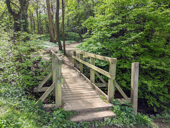
Head SE on Tewin footpath 22 for 370m until you reach a footbridge leading into woodland (location -
https://w3w.co/skins.cloak.edit), see image below.
 |
| Cross the footbridge, still on Tewin footpath 22 |
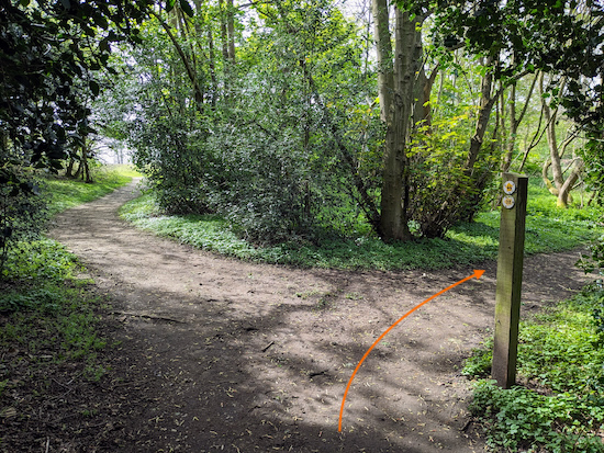
3: Cross the footbridge, still on Tewin footpath 22, then head S through the woodland for 75m until you reach a junction (location -
https://w3w.co/sums.years.wins), see image below.
 |
| Turn right at the junction on Tewin footpath 44 |
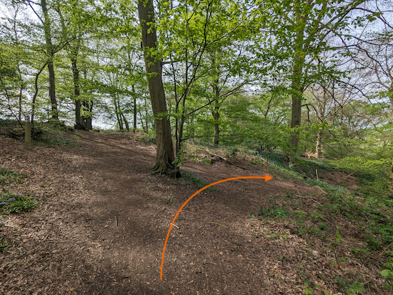
4: Turn right at the junction on Tewin footpath 44 then head through the woodland in a south-westerly direction for 265m until you reach a junction (location -
https://w3w.co/smiles.submit.income), see image below. This section was carpeted with bluebells when we tested this walk in April 2024.
 |
| Turn right on Tewin footpath 18 then head downhill |
5: Turn right on Tewin footpath 18 then head downhill and NW for 55m until you leave the woodland and reach a field (location -
https://w3w.co/player.limbs.look), see image below.
.jpeg) |
| Leave the woodland then head straight and uphill |
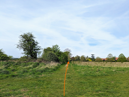
Leave the woodland then head straight and uphill across a field heading WNW for 315m on Tewin footpath 18 until you reach a junction (location -
https://w3w.co/birds.help.treat), see image below.
 |
| Continue heading WNW still on Tewin footpath 18 |
6: When you reach the junction continue heading straight, still on Tewin footpath 18 and still heading WNW, for 130m until you reach Archer's Green Lane (location -
https://w3w.co/string.fines.breath), see image below.
 |
| Cross Archer's Green Lane |
7: Cross Archer's Green Lane then continue, still on Tewin footpath 18 and still heading WNW, for 115m until you reach a junction (location -
https://w3w.co/noon.worry.slowly), see image below.
 |
| Cross the junction then continue heading WNW |
8: Cross the junction then continue heading WNW, still on Tewin footpath 18, for 70m until you reach a gate leading to a churchyard (location -
https://w3w.co/charge.tips.closes), see image below.
 |
| Go through the gate then head WNW through the churchyard |
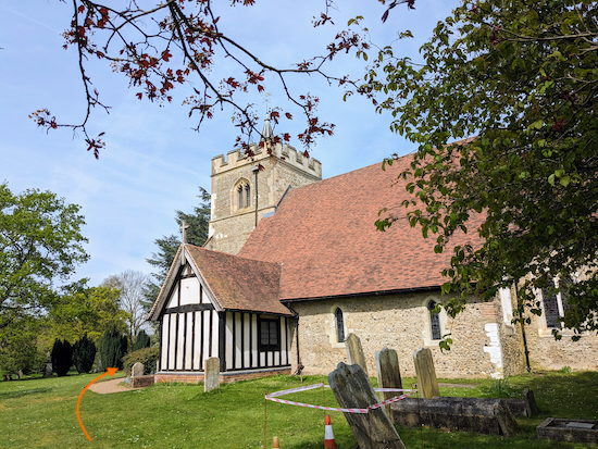
9: Go through the gate then head WNW through the churchyard of the Grade I listed
Church of St Peter, Tewin for 65m until you reach the front of the church. The church has its origins in the 11C.
 |
| The church of St Peter, Tewin |
Turn right in front of the church then head NNW for 25m on Tewin footpath 18 until you come to a tree with a circular bench around the trunk (location -
https://w3w.co/bikes.boots.danger), see image below.
 |
| Turn left after the tree then head W |
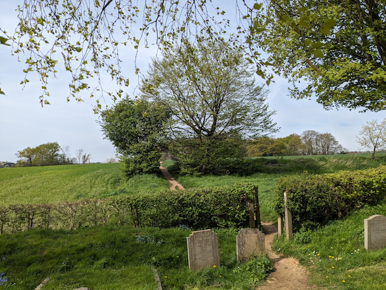
10: Turn left after the tree (see the orange arrow on the image above) then head W for 50m until you reach a gap in the hedgerow where you exit the churchyard (location -
https://w3w.co/nights.feeds.retail), see image below.
 |
| Exit the churchyard still on Tewin footpath 18 |
11: Exit the churchyard then continue heading W, still on Tewin footpath 18, for 120m until you reach a track (location -
https://w3w.co/latest.wipe.rival), see image below.
 |
| Cross the track then continue through woodland |
12: Cross the track then continue, still on Tewin footpath 18 but now heading NW, through woodland for 145m until you reach Churchfield Road (location -
https://w3w.co/give.unless.models), see image below.
 |
| Cross Churchfield Road then continue on Tewin bridleway 7 |
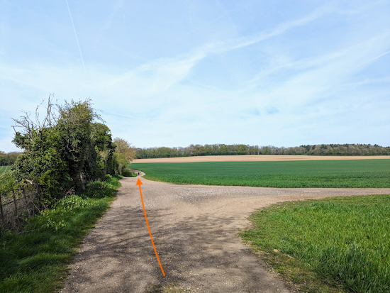
13: Cross Churchfield Road then continue heading NW but now on Tewin
bridleway 7 for 175m until you reach a junction (location -
https://w3w.co/talked.door.error), see image below.
 |
| Continue heading NW, still on Tewin bridleway 7 |
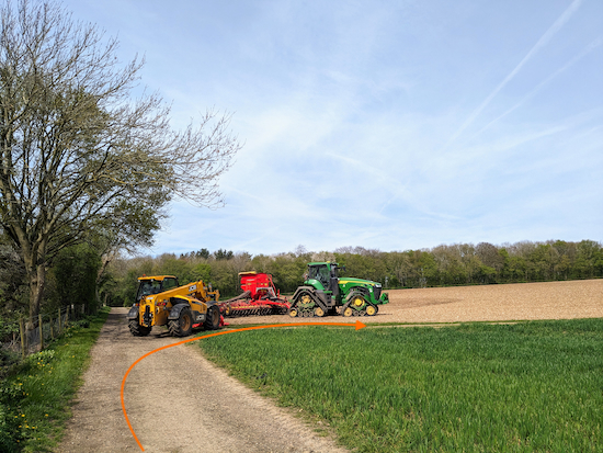
14: Ignore the footpath on the right and continue heading NW, still on Tewin bridleway 7, and with the hedgerow on your left, for 380m until you reach a junction (location -
https://w3w.co/zips.stone.season), see image below.
 |
| Turn right on Tewin footpath 10 |
15: Turn right on Tewin footpath 10 then head NE for 735m to a junction (location -
https://w3w.co/prices.panic.goat), see image below.
 |
| Cross the junction then head NE on Tewin BOAT 1 |
16: Cross the junction then continue heading NE, now on Tewin BOAT 1 (
byway open to all traffic) for 230m to a junction (location -
https://w3w.co/rising.belong.cats), see image below.
 |
| Turn right at the junction on Tewin BOAT 2 |
17: Turn right at the junction on Tewin BOAT 2 then head SSE. After 45m you will see a track and a pond and a bench on the left. An ideal spot for if you want to chill for a moment (location -
https://w3w.co/proof.foam.torch), see image below. The
Plume of Feathers pub/restaurant (location -
https://w3w.co/bike.gloves.spins), although not on our route, is 300m ENE of the bench.
 |
| The bench by a pond to the left of Tewin BOAT 2 |
Continue heading SSE on Tewin BOAT 2 for 430m until the byway bends slightly then heads SE for 215m back to Tewin Village where you will find the
Rose & Crown pub on the left (location -
https://w3w.co/curry.claps.verbs), see image below.
At the time we published this walk (April 2024) the Rose & Crown was temporarily closed while the owner, Greene King Pubs finds a new tenant.
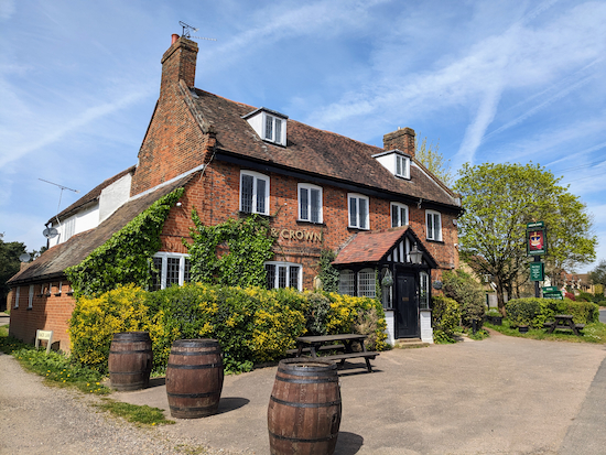 |
| The Rose & Crown, Tewin |
18: Keep heading SE passing Tewin village green on the right (location -
https://w3w.co/bits.myself.leap) and continuing for 240m back to the start of the walk (location -
https://w3w.co/debate.trails.poker).
If you enjoyed this walk please consider joining our
Hertfordshire Walker members-only Facebook Group where you can share photos and comments on your walking experiences.
Interactive map


.jpeg)


No comments:
Post a Comment