5.2 miles (8.4 km) with 71m of total ascent
 |
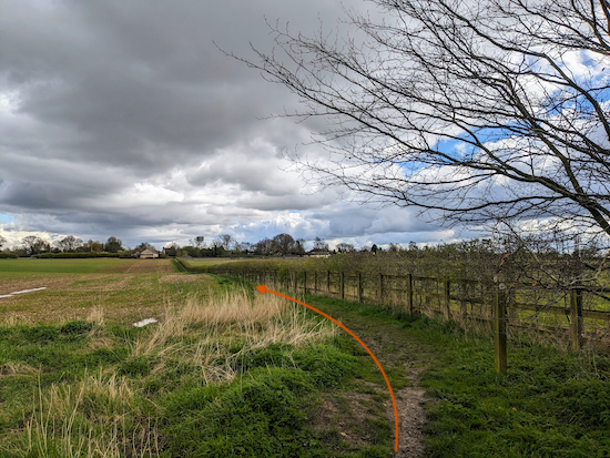
| The footpath between points 12 & 13 in the walk |
This walk covers the rolling countryside west of Kimpton and north of Batford Springs in the north-west of Hertfordshire. The route follows public rights-of-way not previously included in the collection as well as paths that feature in other loops in the area. You will walk along well-defined byways and footpaths and down quiet country lanes. At one point you will dip into Bedfordshire before returning to the starting point at Peter's Green.
We tested this walk on 1 April, 2024 and there were a number of muddy stretches. Waterproof boots and a hiking pole are recommended if you want to follow this route after rain.
Fly through preview of walk
If you want to check what sort of landscape you will be crossing before you set off on this walk you can view a short 3D video of the route below. It's created using the free version of
Relive.
Directions
 |
Map for Walk 253: Peter's Green South-East Loop
Click on the map above for a larger version
Created on Map Hub by Hertfordshire Walker
Elements © Thunderforest © OpenStreetMap contributors
There is an interactive map below these directions |
Those with GPS devices can download
GPX or
KML files for this walk. We've added
What3Words location references for those who use that system. If you print these walks you might want to use the green
PrintFriendly icon at the bottom of these directions to delete elements such as photographs.
 |
| The Bright Star, Peter's Green at the start of the walk |
1: With your back to
The Bright Star (location -
https://w3w.co/kick.easy.thin) turn right then right again on Kimpton Road.
Head ESE along the pedestrian pavement on the north side of Kimpton Road for 250m until you reach a footpath on the right (location -
https://w3w.co/given.unless.paused), see image below.
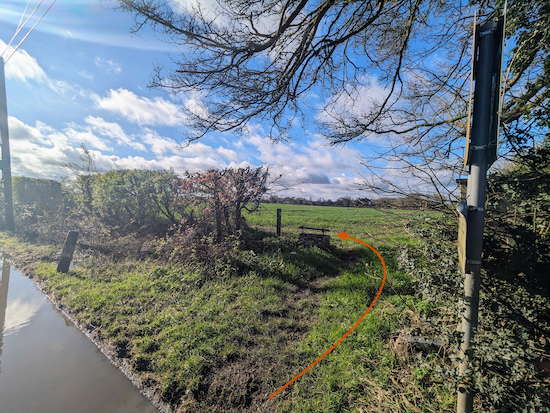 |
| Turn right off Kimpton Road then turn left on a permissive footpath |
2: Turn right off Kimpton Road then turn left on a permissive footpath (see orange arrow on the image above). This path is Kimpton Parish Council's 'Chris Baker Way'. According to the parish council, the late Chris Baker was a parish councillor "who did a lot for Kimpton and the community and so a route was named after him". Continue along this permissive path with the hedgerow on the left and field on the right
After 100m the permissive path becomes Kimpton
footpath 40 and continues heading ESE for 740m until it rejoins Kimpton Road just before houses on the right (location -
https://w3w.co/using.much.sugar).
Continue past the houses then take the footpath on your right immediately after Oak Tree Garage on the right (location -
https://w3w.co/tape.clip.ants), see image below.
 |
| Turn right, still on Kimpton footpath 40 |
Turn right, still on Kimpton footpath 40, then continue heading ESE for 230m until you reach a lane on the right which is also Kimpton
bridleway 59 (location -
https://w3w.co/placed.basis.activism).
3: Turn right on Kimpton bridleway 59 then head S and SSE for 220m until you reach a gate (location -
https://w3w.co/angel.cross.wins) see image below.
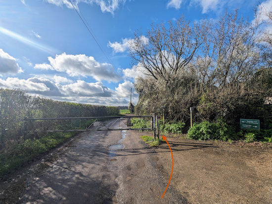 |
| Go through the gate then continue on Kimpton bridleway 59 |
Go through the gate then continue to follow Kimpton bridleway 59 SSE until it bends right (location -
https://w3w.co/scales.lush.words) then heads WSW for 30m to a junction (location -
https://w3w.co/basin.detail.pounds), see images below.
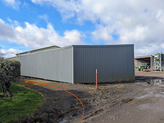 |
| Turn left on Kimpton bridleway 41 |
 |
| Kimpton bridleway 41 beyond the farm |
4: Turn left on Kimpton bridleway 41 then head S then SSW for 270m until you reach a junction (location -
https://w3w.co/treat.behind.photos), see image below.
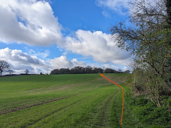 |
| Continue on Kimpton bridleway 41 as it heads SSW and uphill |
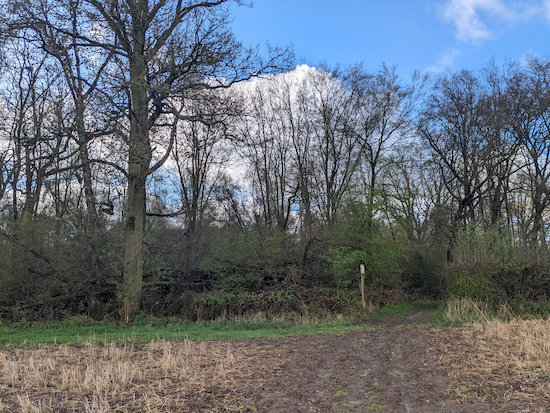
5: Ignore a footpath on the left and continue on Kimpton bridleway 41 as it heads SSW and uphill across an arable field for 265m before reaching woodland (location -
https://w3w.co/gains.second.beside), see image below.
 |
| Enter the woodland, now on Wheathampstead bridleway 19 |
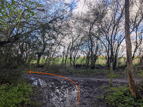
6: Enter the woodland, now on Wheathampstead bridleway 19, then head SW through the woodland for 115m until you reach a junction (location -
https://w3w.co/island.bowls.await), see image below.
 |
| Turn left on Wheathampstead restricted byway 8 |
7: Turn left on Wheathampstead
restricted byway 8 then head S for 520m until you reach the B652, Kimpton Bottom (location -
https://w3w.co/salt.snail.lakes), see image below.
 |
| Turn left on Kimpton Bottom |
8: Turn left on Kimpton Bottom then head ESE for 65m until you reach Common Lane on the right (location -
https://w3w.co/rises.loops.necks).
Turn right on Common Lane then head SSE for 440m ignoring Holly Lane on the left (location -
https://w3w.co/join.keeps.squad) and continuing to a point where Common Lane forks (location -
https://w3w.co/went.epic.wisdom), see image below.
.jpeg) |
| Continue heading SSE and straight |
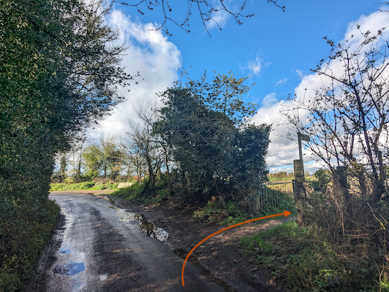
9: Continue heading SSE and straight, taking the left fork ignoring the turn on the right. Follow Common Lane SSE for 620m ignoring the first footpath on the right (location -
https://w3w.co/stable.lined.soap), but taking the second footpath on the right immediately before a bend (location -
https://w3w.co/guides.flame.jazz), see image below.
 |
| Take the footpath on the right off the lane |
10: Turn right on a footpath which straddles a parish boundary and is both Harpenden footpath 31 and Wheathampstead footpath 60 along the next stretch.
On your right you will see the
Hornbeam Wood Hedgehog Sanctuary.
Follow this footpath as it heads NW for 390m before reaching woodland (location -
https://w3w.co/slot.stocks.store) where the path you are on continues as Wheathampstead footpath 60 only.
Continue NW for another 195m until you reach Bower Heath Lane, the B652 (location -
https://w3w.co/orders.drops.cuts).
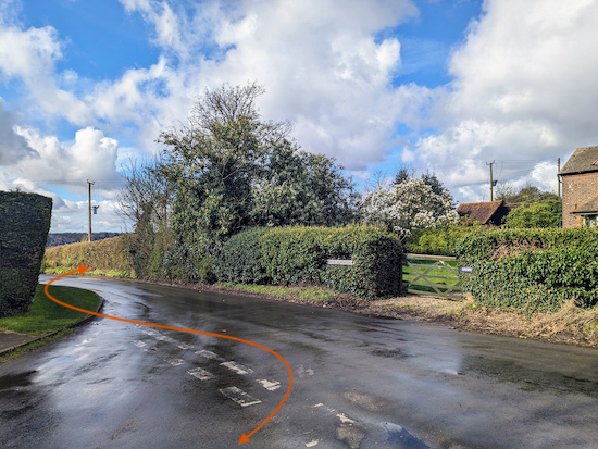
11: Turn left on Bower Heath Lane then head SW for 50m looking out for a footpath on your right, see image below.
 |
| Turn right on Harpenden footpath 30 |
Turn right on Harpenden footpath 30 then head WNW for 75m before the footpath bends to the right (location -
https://w3w.co/lamp.visits.tribe) where it becomes Wheathampstead footpath 93.
Follow Wheathampstead footpath 93 N, NW, then N again for 305m until you reach a junction (location -
https://w3w.co/curl.editor.search), see image below.
 |
| Turn left at the junction on Wheathampstead footpath 51 |
12: Turn left at the junction on Wheathampstead footpath 51 then head NW for 405m to a junction (location -
https://w3w.co/lively.caring.face), see image below.
 |
| Turn right on Wheathampstead footpath 52 |
13: Turn right on Wheathampstead footpath 52 then head NE for 145m until the track bends left and the footpath you are on bends right (location -
https://w3w.co/range.bugs.elaborate), see image above.
 |
| Follow Wheathampstead footpath 52 as it bends right |
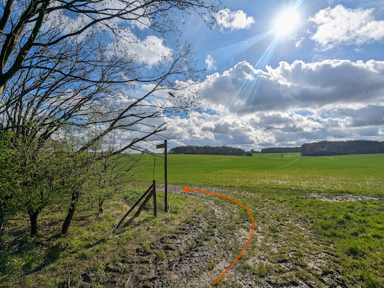
14: Follow Wheathampstead footpath 52 as it bends right then heads SE for 30m before turning left (location -
https://w3w.co/museum.hatch.opens), see image below.
 |
| Continue on Wheathampstead footpath 52 now heading NE |
Continue on Wheathampstead footpath 52 now heading NE for 355m, with the hedgerow on the left and field on the right, until you reach a gap in the hedge (location -
https://w3w.co/sheep.photo.novel), see image below.
 |
| Where the path appears to fork take the right fork |
15: Where the path appears to fork take the right fork (see orange arrow on the image above) then continue heading NE, still on Wheathampstead footpath 52, and still with the hedgerow on the left and field on the right, for 210m until you reach a gate leading to a metalled track (location -
https://w3w.co/stick.rats.water), see image below.
.jpeg) |
| Go through the gate then turn right on a metalled track |
Go through the gate, turn right on the metalled track, then head NE and downhill for another 95m until you reach a junction just beyond a cottage on the left (location -
https://w3w.co/stay.spend.less), see image below.
 |
| Turn left on Wheathampstead restricted byway 5 |
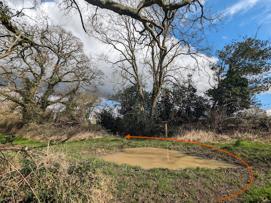
16: Turn left on Wheathampstead restricted byway 5 then head N for 290m then follow the byway as it bends right (location -
https://w3w.co/poker.safe.detail) before heading NE for 220m to reach the point where the byway leaves Hertfordshire and enters Bedfordshire and the colour of the marker posts and signs change (location -
https://w3w.co/vines.also.spoon), see image below.
 |
| Turn left then head NW for 755m along this restricted byway |
17: Turn left then head NW for 755m along this restricted byway in the Bedfordshire parish of Hyde, continuing until you reach Farr's Lane (location -
https://w3w.co/rents.bulb.rank), see image below.
 |
| Turn right on Farr's Lane then head NW |
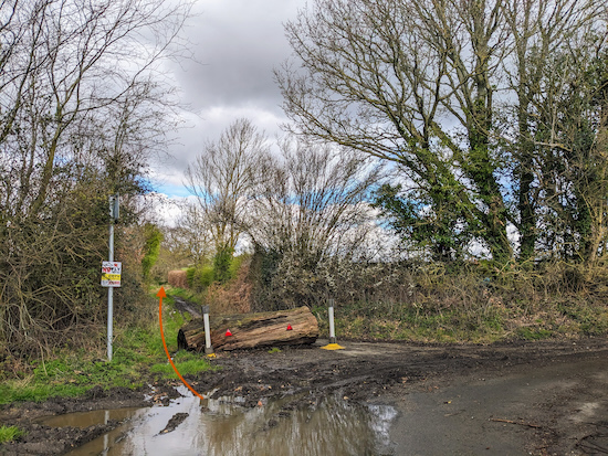
18: Turn right on Farr's Lane then head NW for 170m to the point where the lane bends right and the restricted byway branches left to continue heading NW (location -
https://w3w.co/precautions.study.dish), see image below.
 |
| Turn left off Farr's Lane then continue along the restricted byway |
19: Turn left off Farr's Lane then continue heading NW along the restricted byway until you reach a footpath on the right (location -
https://w3w.co/tips.gossip.sands), see image below. This junction can be hard to find so I have added a close-up of the map showing the way.
 |
| Turn right on Kimpton footpath 47 |
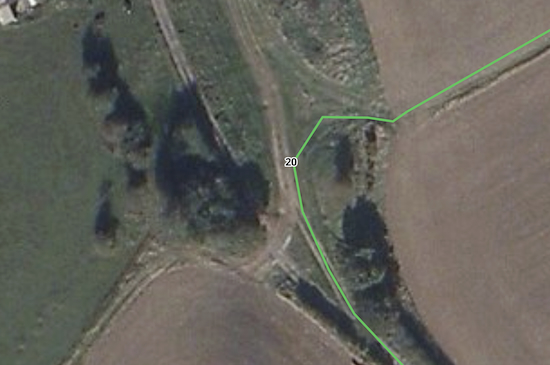 |
| A close-up of the map showing the the turn for Kimpton footpath 47 |
20: Turn right on Kimpton footpath 47 then head NE for 380m, see image below.
 |
| Kimpton footpath 47 heading towards Peter's Green |
Continue on Kimpton footpath 47 until you reach Chiltern Green Road in Peter's Green (location -
https://w3w.co/heave.august.sample).
21: Turn right on Chiltern Green Road then head SE for 170m back to the starting point (location - ).
If you enjoyed this walk please consider joining our
Hertfordshire Walker members-only Facebook Group where you can share photos and comments on your walking experiences.
Interactive map


.jpeg)


.jpeg)


No comments:
Post a Comment