2.8 miles (4.5 km) with 71m of total ascent
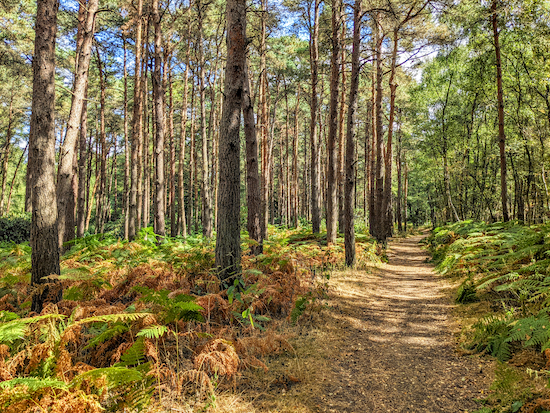 |
| North Mymms restricted byway 3 between points 2 & 3 |
This short walk starts at The Black Horse in South Mimms then heads through the beautiful Mymmshall Wood and Hawkshead Wood before looping back across fields offering wide open views across south Hertfordshire. There is 630m of lane walking at the start, but it's a quiet lane and we didn't encounter any traffic. You will cross one field where horses were grazing when we tested the walk, but they didn't bother us. You will be aware of noise from the M25 and the A1(M) at certain points. The starting point is 2.3 miles W from Potters Bar station by road.
* If you are following this route in the summer or early autumn you might want to take a pair of secateurs and a stick with you to help deal with any brambles or nettles.
Directions
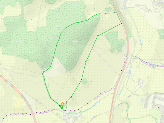 |
Map for Walk 196: South Mimms North Loop
Click here or on the map for a larger version
Created on Map Hub by Hertfordshire Walker
Elements © Thunderforest © OpenStreetMap contributors
There is an interactive map below the directions |
Those with GPS devices can download
GPX or
KML files for this walk. We've added
What3Words location references for those who use that system. If you print these walks you might want to use the green
PrintFriendly icon at the bottom of these directions to delete elements such as photographs.
 |
| The Black Horse, South Mimms |
1: With your back to
The Black Horse (location -
https://w3w.co/closes.debit.onion) turn right then head NW along Blackhorse Lane for 630m until the lane bends left at a triangular junction (location -
https://w3w.co/coats.couple.plays). Keep right at the junction then take the track on your right immediately before two brick pillars and a cottage (location -
https://w3w.co/finger.clay.quest), see image below. This is Ridge
restricted byway 11.
 |
| Turn right on Ridge restricted byway 11 |
2: Follow Ridge restricted byway 11 NE and uphill for 200m until you pass the last farm building on the right (location -
https://w3w.co/salt.spring.vines) at which point the track you are on becomes North Mymms restricted byway 3. Follow this woodland byway uphill and past Mymmshall Wood on the right and Hawkshead Wood on the left, see images below.
 |
| North Mymms restricted byway 3 with Mymmshall Wood on the right |
 |
| North Mymms restricted byway 3 with Hawkshead Wood on the left |
Continue for 1.4km until you descend the hill and reach a split in the track (location -
https://w3w.co/comical.stick.reject), see image below.
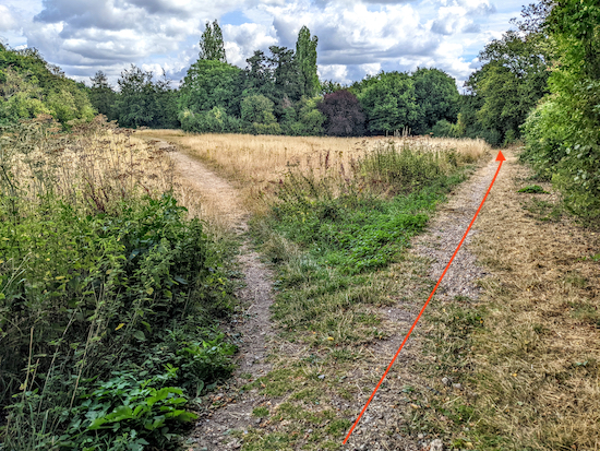 |
| Keep right at the fork, still on North Mymms restricted byway 3 |
Keep right at the fork, still on North Mymms restricted byway 3, then head E for 95m until you reach a junction (location -
https://w3w.co/booth.topped.ridge), see image below.
 |
| Take the footpath on the right immediately after the aluminium gateway |
3: Take the
footpath on the right immediately after the aluminium width restriction (location -
https://w3w.co/edits.sage.stays).
If you start to cross the bridge over the A1(M) you have gone too far. Follow South Mimms footpath 23 SSE for 10m to an aluminium gate (location -
https://w3w.co/cards.guitar.listed).
* A local walker has pointed out that this gate can become overgrown with nettles and brambles in the summer/autumn.
After going through the gate the footpath heads E for 25m before reaching a hedgerow running SSE alongside the A1(M) (location -
https://w3w.co/hints.units.tested). South Mimms footpath 23 turns right here and continues with the hedgerow on the left and the field on the right, see image below.
 |
| Head SSE on South Mimms footpath 23 with the A1(M) on the left |
Continue heading SSE along South Mimms footpath 23 with the A1(M) on the left for 170m until the footpath becomes a concrete track. Continue for 20m looking for a footpath on the right cutting across a field (location -
https://w3w.co/inform.sample.organs), see image below.
I have added orange marker arrows on the following images because the footpath might not be obvious once the field is ploughed and before
the public right of way is reinstated.
 |
| Turn right then head WSW still on South Mimms footpath 23 |
 |
| Cross the field heading WSW on South Mimms footpath 23 |
|
4: Turn right, then head WSW, still on South Mimms footpath 23, for 330m until you pass woodland on the left (location -
https://w3w.co/tigers.dare.region), see image below.
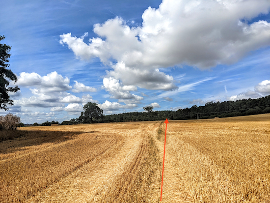 |
| After the woodland on the left follow the line of the orange arrow |
Keep straight when you pass the woodland on the left, still heading WSW and still on South Mimms footpath 23, for 100m until you reach a marker post on the left (location -
https://w3w.co/mile.such.wire), see image below.
 |
| After the marker post head SW, still on South Mimms footpath 23 |
5: Head SW, still on South Mimms footpath 23, for 190m until you reach a telegraph pole on the right (location -
https://w3w.co/mental.hails.suffice), see image below.
 |
| Keep to the left of the telegraph pole then head SSW |
Keep to the left of the telegraph pole then head SSW for 270m until you reach a marker post at the left of a line of trees (location -
https://w3w.co/newly.tiny.minds), see image below.
 |
| Head SSW, still on South Mimms footpath 23 towards the woodland |
6: Head SSW, still on South Mimms footpath 23, for 320m until you reach woodland (location -
https://w3w.co/gossip.sudden.boring), see image below.
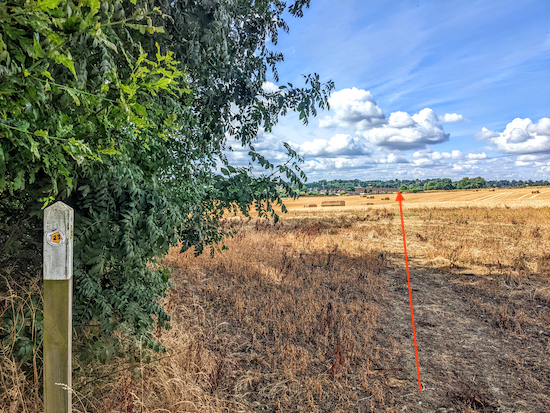 |
| Head SW, still on South Mimms footpath 23, to a marker post |
7: With the woodland on your left, head SW, still on South Mimms footpath 23, for 310m until you reach a marker post next to a telegraph pole (location -
https://w3w.co/pints.drum.backup), see image below.
 |
| Continue heading SW across a field to an aluminium gate |
8: Continue heading SW, still on South Mimms footpath 23, for 120m until you reach an aluminium gate (location -
https://w3w.co/discrepancy.jukebox.bigger).
* When we tested this route on 4 August 2022 this field was knee high in clover and there were nettles and brambles around the aluminium gate. We managed to make our way through without any problem, but we recommend you take a pair of secateurs and a stick in case the nettles and brambles are a problem. The encroachment has been reported to Hertfordshire County Council's Rights of Way team as usual. See our tips page for how to report encroachment to public rights of way. See image of the clover field and the direction of the footpath marked in orange below.
 |
| Head SW on South Mimms footpath 23 until you reach a gate |
9: Once through the aluminium gate turn left then head SE for 20m before the path swings right (location -
https://w3w.co/frogs.jacket.middle), see images below.
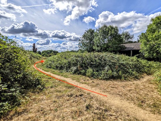 |
| Turn left after the aluminium gate |
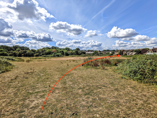 |
| Follow the path SSW for 115m until you reach a metal gate |
Follow the path SSW for 115m until you reach a metal gate leading to houses (location -
https://w3w.co/sharp.pinch.loops), see image below.
 |
| Once through the gate follow the path to Blackhorse Lane |
10: Once through the gate follow the path through the houses to Blackhorse Lane (location -
https://w3w.co/envy.drums.trend). Turn right on Blackhorse Lane then head N back to The Black Horse and the starting point.
Interactive map


No comments:
Post a Comment