6.3 miles (10.1km) with 174m of total ascent
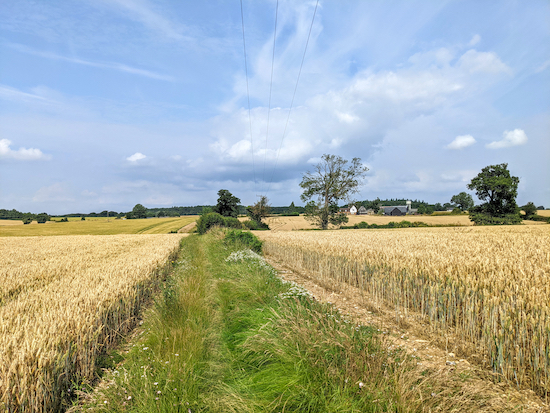 |
| Offley footpath 4 between points 5 & 6 |
This is a lovely walk through the rolling countryside east of Luton airport. It passes three pubs, with another a short detour from the main route. There are a couple of footpaths which were overgrown when we did this walk in July 2021. We always carry a stick and a pair of secateurs to push back any nettles or cut back any overhanging brambles. Long trousers would probably be a good idea. All the footpaths were passable when we did the walk. There is one stretch between points 18 & 19 where we had to navigate over a ploughed field. We have added an image and an extra map to help with this short section.
Directions
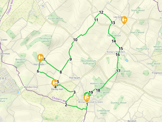 |
Map for Walk 152: Breachwood Green North Loop
Click here for a larger version of the map
Created on Map Hub by Hertfordshire Walker
Elements © Thunderforest © OpenStreetMap contributors
There is an interactive map below the directions |
Those with GPS devices can download
GPX or
KML files for this walk. We've added
What3Words location references for those who use that system. If you print these walks you might want to use the green
PrintFriendly icon at the bottom of these directions to delete elements such as photographs.
 |
| The Red Lion, Breachwood Green - the start and finish point |
1: As you face
The Red Lion pub/restaurant at the junction of Oxford Road and Chapel Road in Breachwood Green (location -
https://w3w.co/handle.tutored.nametag), turn left then head S along Chapel Road for 200m until you reach a footpath on your right (location -
https://w3w.co/secrets.crowned.gossiping), see image below.
 |
| Kings Walden footpath 6 heading W |
Turn right on Kings Walden footpath 6 then head WNW, SW, WNW, then N for 340m until you reach a junction (location -
https://w3w.co/shut.wishes.horses).
 |
| Turn right at the tree then head N to the junction mentioned above |
2: At the junction turn left, still on Kings Walden footpath 6, then head WNW for 340m until the footpath bends to the right then heads N for 20m to a junction (location -
https://w3w.co/pest.spins.tidy), see image below.
 |
| Keep right at the junction then follow Kings Walden bridleway 52 |
Keep right at the junction, now on Kings Walden bridleway 52, then head N then NE for 450m until you reach Brownings Lane (location -
https://w3w.co/spare.match.spike).
3: Turn left on Brownings Lane, then head NW for 45m looking for a footpath on the left (location -
https://w3w.co/insect.vets.just), see image below.
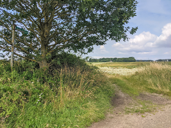 |
| Kings Walden footpath 9 heading WSW |
Turn left on Kings Walden footpath 9 then head WSW then NW for 470m until you reach Darley Road (location -
https://w3w.co/estate.scale.think). Turn left on Darley Road then head SW and downhill for 170m until you reach
The Fox pub/restaurant on your left (location -
https://w3w.co/delay.cape.stops).
Look out for a footpath on the right as you reach the pub. There are two footpaths at this point, make sure you take the one on the right, see the yellow arrow in the image below.
 |
| Take the footpath on the right - see the yellow arrow |
4: Take this footpath, Kings Walden footpath 11, and follow it NE for 110m through a patch of woodland before leaving the woodland and continuing, with the hedgerow on the right and field on the left, for 80m to a junction (location -
https://w3w.co/plan.being.orbit), see image below.
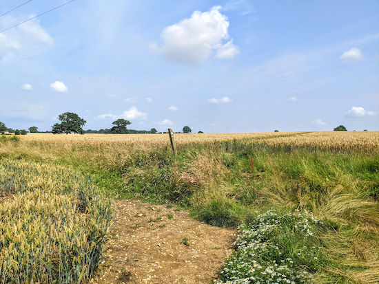 |
| Turn left at the junction on Offley footpath 4 |
5: Turn left at the junction on Offley footpath 4 then head NW for 420m passing Tankards Farm on the right (location -
https://w3w.co/blank.patrol.porch), part of which is
grade II listed by
Historic England. At this point Offley footpath 4 ends and you continue for another 270m along a farm lane, still heading NW, until you reach Stony Lane (location -
https://w3w.co/raced.year.porch).
6: Turn right on Stony Lane then head NNE for 280m until you reach Tea Green and
The White Horse pub/restaurant (location -
https://w3w.co/noises.achieving.unless). Walk past The White Horse and continue heading NE along Stony Lane for 170m looking out for a footpath on the right (location -
https://w3w.co/boss.nuns.wiring) after a cottage on the right, see image below.
 |
| Offley footpath 6 heading SE from Stony Lane |
7: Turn right on Offley footpath 6 then head SE for 160m to a junction (location -
https://w3w.co/found.soft.park). Keep left at the junction, still on Offley footpath 6, and continue to head SE for 470m until you reach a footpath on your left going through the crop (location -
https://w3w.co/mixer.faded.grants), see image below.
 |
| Kings Walden footpath 11 turning left through the crop |
8: Turn left on Kings Walden footpath 11 then follow it NE for 140m until you reach a break in the field (location -
https://w3w.co/truck.valley.dull). Continue through the next field heading NE, still on Kings Walden footpath 11, for 290m until you reach the field boundary where the path bends to the right into woodland (location -
https://w3w.co/saving.fields.drill). Drop down a set of steps to reach a field leading to a gate, see image below. Go through the gate, down some more steps leading to a junction (location -
https://w3w.co/fingernails.violin.hotel).
 |
| After the steps, cross the crop in direction of the gate - point 8 |
9: Turn left on Kings Walden footpath 33 then follow it N then NE for 660m to a lane called Lilley Bottom (location -
https://w3w.co/socket.swept.camera). This section was a bit overgrown when we walked it.
10: Cross the lane then take Kings Walden footpath 12 following it NE for 920m to Kings Walden Road (location -
https://w3w.co/forklift.exacted.wipes). The first part of this path was a bit overgrown when we walked the route, but we were able to get through by pushing the nettles back with a stick.
 |
| Kings Walden footpath 12 heading NE - point 10 |
11: When you reach Kings Walden Road turn left then head NW for 70m until you reach Kings Walden footpath 49 on the right (location -
https://w3w.co/sprinter.prevented.drifters), see image below.
 |
| Kings Walden footpath 49 heading NE of Kings Walden Road |
Follow this footpath NE for 250m to a junction (location -
https://w3w.co/vies.save.plausible), see image below.
 |
| The junction with Kings Walden footpath 25 |
12: Turn right on Kings Walden footpath 25 then follow it SE for 460m until you reach School Lane, Ley Green (location -
https://w3w.co/samplers.toggle.glaze).
* At this point you have the option of visiting The Plough in Ley Green (location - https://w3w.co/slope.soothing.laughs). To do so, turn left on School Lane then head NE for 210m until you reach a road junction. Turn right looking out for Kings Walden footpath 26 on your right (location - https://w3w.co/prowess.fatherly.synthetic) which you follow SE for 240m until you reach a lane. Turn right on the lane and The Plough will be on your right. Return the same way to rejoin the route.
13: Turn right on School Lane then head SW for 50m to a junction (location -
https://w3w.co/print.rails.exploring). Keep right at the junction and continue for 50m, still heading SW, until you reach Kings Walden footpath 22 (location -
https://w3w.co/saunas.challenge.richest), see image below.
 |
| Kings Walden footpath 22 heading SSW |
Follow Kings Walden footpath 22 SSW then S for 280m until the footpath bends to the left (location -
https://w3w.co/eyepieces.talent.chatted) then heads SE past a barn on the left (location -
https://w3w.co/roosts.inclined.reforming) then through woodland to reach a field (location -
https://w3w.co/sleeps.plantings.royal). Follow the path to the right then head SSW to a junction (location -
https://w3w.co/pulses.lavished.pranced).
14: Turn left on Kings Walden footpath 24 then head SE for 300m until you reach Church Road (location -
https://w3w.co/roofs.extremes.escalated).
15: Turn right on Church Road then follow it SSW for 200m until you reach a right-hand bend with a footpath on the left (location -
https://w3w.co/stack.workflow.marriage), see image below.
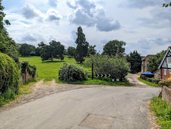 |
| Kings Walden footpath 19 on the left before the bend |
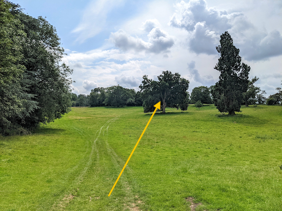
16: Take the footpath on the left, Kings Walden footpath 19, then head S then SSW uphill for 390m until you reach woodland (location -
https://w3w.co/landlady.informer.surfed), see line of yellow arrow in the image below.
 |
| Head uphill following the line of the yellow arrow - point 16 |
Continue heading S through the woodland until you reach a junction (location -
https://w3w.co/blissful.pickup.scratches), see image below.
 |
| Kings Walden footpath 14 going off to the right - can be overgrown |
17: Turn right on Kings Walden footpath 14 then head SW. This part can be overgrown with nettles. Continue until you reach a gate leading to a field, see image below. Cross the field heading SW and downhill for 370m until you reach Lilley Bottom Road (location -
https://w3w.co/feuds.putter.landscape).
 |
|
Cross the field heading in the direction of the yellow arrow - point 17 |
Cross Lilley Bottom Road then continue heading SW but now uphill on Kings Walden footpath 14 for 240m until you reach woodland (location -
https://w3w.co/qualifier.uncouth.paint).
Continue through the woodland, still heading SW on Kings Walden footpath 14 for 210m until you reach a gate leading to a field.
18: Go through the gate, turn right, then head NW with the woodland on your right and a field on your left for 80m until you reach a signpost on the right (location -
https://w3w.co/bashful.eyelid.stun). Turn left then cross the field heading SW for 170m until you reach a signpost in the middle of the field (location -
https://w3w.co/rigid.pulled.agency).
* When we did this walk on 26 July 2021 the field had just been ploughed and the path had not been reinstated, so we have added a yellow arrow on the image below and created a map to help you navigate this next section because we were using GPS navigation but it might be difficult for those using maps.
The first image shows the route across the field. Aim for the white-topped post just to the left of the white house. The map below shows the route in a satellite map image.
 |
| Cross the field heading towards the white-topped post to the left of the house |
 |
| The route across the field after point 18 * |
19: When you reach the signpost in the field turn left on Kings Walden footpath 15 then head S for 80m to the edge of the field where you turn right then head W walking along the edge of the field 90m looking out for a footpath on your left. Take this path, still Kings Walden footpath 15 then head S then SW for 150m back to Breachwood Green where you turn left and head S for 100m back to The Red Lion and the start point.
* Sources for the satellite map: Esri, DigitalGlobe, GeoEye, Earthstar Geographics, CNES/Airbus DS, USDA, USGS, AEX, Getmapping, Aerogrid, IGN, IGP, swisstopo, and the GIS User Community
Interactive map


Comments
Post a Comment