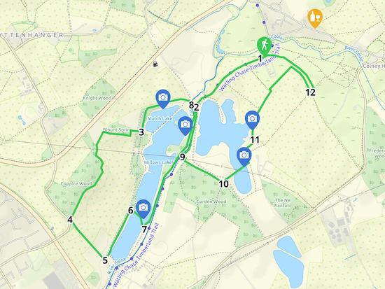
4.5 miles (7.2 km) with 64m of total ascent
 |
Directions
 |
| Map for Walk 110: Willows Lakes Loop Created on Map Hub by Hertfordshire Walker Elements © Thunderforest © OpenStreetMap contributors There is an interactive map below the directions |
Please keep to the public rights of way on this walk. We have included a map at the foot of this page showing the public rights of way around Willows Lakes in green and the paths reserved for those fishing the lakes in red.
1: Find a parking place along Church Lane (location - https://w3w.co/before.terms.author), please check in case any parking restrictions have been introduced since this walk was published. Head SSE along Church Lane, then follow the lane as it turns to the right and heads SW before becoming Ridge bridleway 2 (location - https://w3w.co/editor.train.ritual). Follow Ridge bridleway 2 for 670m which at this point is also the Watling Chase Timberland Trail. You will cross a gravel track used by quarry vehicles (location - https://w3w.co/supporter.status.hurray) and then a wooden bridge spanning a conveyor belt (location - https://w3w.co/gear.socket.grant) before reaching a junction (location - https://w3w.co/gasp.marble.ruins).
2: Turn right on Ridge bridleway 6 then head NW for 20m, cross a bridge over the River Colne (location - https://w3w.co/wants.lame.gross) and continue heading NW for 30m until you reach Ridge footpath 1 on your left which runs just to the right of the green portable cabins (location - https://w3w.co/start.supporter.pool). Head WSW for 310m on Ridge footpath 1 then take the path on the left which runs through the woods (location - https://w3w.co/inform.prefer.wins). Continue heading SSW, still Ridge footpath 1, for 180m until you reach a footpath on the right going through a small parking area (location - https://w3w.co/chest.ramp.escape).
3: This is Ridge footpath 33. Follow it for 1.1km, first W, S then W again past Blount Spring (woodland) on your right, then SSW, S, SE, and SW past Coppice Wood on your right and continue until you reach a junction (location - https://w3w.co/type.period.level).
4: At the junction turn left and head SE on London Colney footpath 38 for 400m until you reach another junction (location - https://w3w.co/glass.detect.bugs).
5: Take the first turn on your left, Ridge footpath 1, through another parking area and up a gravel path heading NNE for 420m until you reach a footpath on the right (location - https://w3w.co/verbs.choice.trial).
 |
| The view from Ridge footpath 50 mentioned in point 6 |
 |
| The view from Ridge footpath 2 just before you reach point 8 |
8: Turn right here on Ridge bridleway 6, cross the bridge, turn right then head SSW for 450m until you reach a track on the left (location - https://w3w.co/silent.hill.allow).
9: Turn left here, still on Ridge bridleway 6, and head first ESE, then SSW, then SE for 390m until you reach a track on the left (location - https://w3w.co/august.played.falls).
 |
| The view from Ridge footpath 4 mentioned in point 10 |
11: Take this path, Ridge footpath 48, and head NW, N, then NE for 420m until you reach Colney Heath bridleway 32 where you turn right and head NE for 230m before turning right and heading SSE for 220m to a track on the left (location - https://w3w.co/soon.twist.shops).
12: Take this path and turn left in the woods heading NW for 440m picking up Colney Heath footpath 35 back to the starting point.
Rights of way and private paths
 |
| Public rights of way in green, private fishing paths in red The green markers show two land-bridge across the lakes Click here or on image for larger version Created on Map Hub by Hertfordshire Walker Elements © Thunderforest © OpenStreetMap contributors |
Comments
Post a Comment