5.7 miles (9.3km) with 140m of total ascent
 |
| Hexton footpath 2 between points 14 & 15 |
This is an excellent walk from the village of Hexton. It starts and finishes at The Raven pub/restaurant before crossing the border into Bedfordshire then following a section of The Chiltern Way over the Pegsdon Hills. The route then loops back along part of The Icknield Way before returning to Hexton along a lovely path between Lion Hill and Moor Hill, see image above.
The starting point for this walk is 6.5 miles west from Hitchin Station by road.
Fly through preview of walk
If you want to check what sort of landscape you will be crossing before you set off on this walk you can view a short 3D video of the route below. It's created using the free version of
Relive.
Directions
 |
Map for Walk 237: Hexton South-East Loop
Click on the map above for a larger version
Created on Map Hub by Hertfordshire Walker
Elements © Thunderforest © OpenStreetMap contributors
There is an interactive map below these directions |
Those with GPS devices can download
GPX or
KML files for this walk. We've added
What3Words location references for those who use that system. If you print these walks you might want to use the green
PrintFriendly icon at the bottom of these directions to delete elements such as photographs.
The village of Hexton is bordered by Bedfordshire to the west, north and east. To enable us to create a loop, about a quarter of this walk (2.5 km) is in Bedfordshire.
 |
| The Raven in Hexton village at the start of the walk |
1: With your back to
The Raven pub/restaurant (location -
https://w3w.co/panther.incoming.escalates) turn left then head N for 460m until the road bends sharp right (location -
https://w3w.co/trials.vine.thrashed) see image below.
 |
| Follow the road as it bends right then heads eastwards |
2: Follow the road, which is also
The John Bunyan Trail at this point, as it bends right then heads eastwards for 530m until the lane peters out and becomes Shillington
bridleway 4 at the point where Hexton Mill once stood. You are now entering Bedfordshire (location -
https://w3w.co/shopping.take.champions). 30m beyond the site of the old mill you will reach a fork, see image below.
 |
| Take the left fork then head E on Shillington bridleway 4 |
3: Take the left fork then continue heading E on Shillington bridleway 4 for 240m until you reach a junction (location -
https://w3w.co/applies.pokers.burglars) see image below.
 |
| Turn right at the junction then head S |
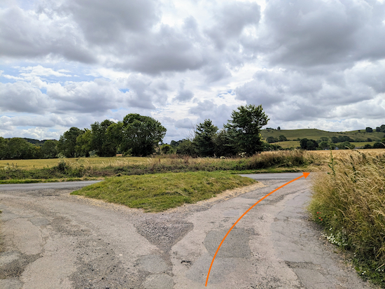
4: Turn right at the junction then head S, still on Shillington bridleway 4, for 120m then SE for 510m until you reach Apsley End Road (location -
https://w3w.co/tangent.central.seemingly) see image below.
 |
| Turn right on Apsley End Road |
5: Turn right on Apsley End Road then head SSW for 250m until you reach a junction (location -
https://w3w.co/seasick.applauded.chimp) see image below.
* If you need refreshments, The View is 200m to the left down Pegsdon Way.
 |
| Keep right at the junction |
6: Keep right at the junction then head SW along Apsley End Road, which is also
The Chiltern Way Northern Extension along this stretch. Continue for 130m to another junction (location -
https://w3w.co/sketch.iterative.reversed) see image below.
 |
| Keep right at the junction |
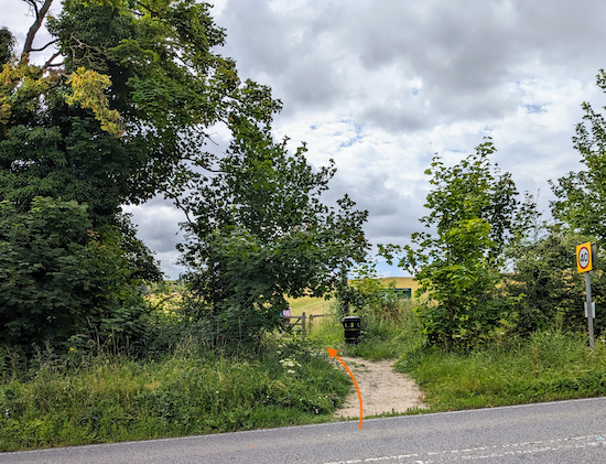
Keep right at the junction then follow a dead-end road SW for 100m until you reach the B655 (location -
https://w3w.co/catchers.residual.denser) see image below.
 |
| Cross the B655 then take the footpath on the other side |
7: Cross the B655 then take the
footpath on the other side at one of the entrances to the
Pegsdon Hills and Hoo Bit nature reserve , see image below.
 |
| The gate into the Pegsdon Hills nature reserve |
 |
| Information board at Pegsdon Hills |
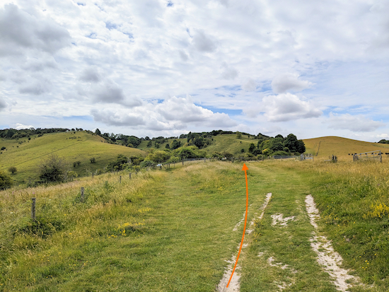
Follow the footpath, which is Shillington footpath 17 and also The Chiltern Way Northern Extension, uphill for 420m until you come to two gates (location -
https://w3w.co/wisely.preparing.before), see image below.
 |
| Go through the gate on the right |
Go through the gate on the right, see image below.
 |
| Go through the gate then continue uphill |
Go through the gate then continue uphill for 340m until you reach another gate (location -
https://w3w.co/cure.short.forehand), see images below.
 |
| The path leading to the top of Pegsdon Hills |
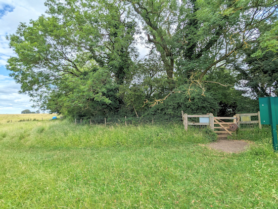
Go through the gate then continue, now heading SE, for 195m until you pass through another gate, then continue for 230m until you meet
The Icknield Way at a T-junction. You are now back in Hertfordshire (location -
https://w3w.co/nickname.beaker.structure) see image below.
 |
| The gate leading to The Icknield Way |
8: Turn right on The Icknield Way, which is also Lilley BOAT (
byway open to all traffic) 24, then head SW for 60m until you reach a junction (location -
https://w3w.co/overruns.parkland.fools), see image below.
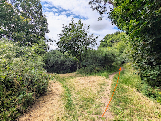 |
| Keep right at the junction |
Keep right at the junction then head SW for 1.5 km until you reach Hexton Road (location -
https://w3w.co/wheels.slick.gear) see image below.
 |
| Follow a footpath along the right side (north side) of Hexton Road |
9: Continue heading straight and SW along Hexton Road following a footpath which has been cut through the grass verge running along the right side (north side) of Hexton Road, see orange arrow on the image above. Continue along this path for 500m until Hexton Road bends to the left at a byway (location -
https://w3w.co/trash.dizzy.cloth) continues heading straight and SW, see image below.
 |
| Take the byway on the bend and continue heading SW |
10: Take this byway, which is both Lilley BOAT 23 and Hexton BOAT 8, as it heads SW along a parish boundary for 345m until it reaches a junction (location -
https://w3w.co/almost.luxury.packet) see image below.
 |
| Turn right on Hexton bridleway 1 |
11: Turn right on Hexton bridleway 1 then head N for 370m until you reach a farmyard (location -
https://w3w.co/tricky.spent.riders), see image below.
 |
| Continue heading N, with the farm on your right |
Continue heading N on Hexton bridleway 1, with the farm on your right, for 250m until you reach Streatley Road (location -
https://w3w.co/sides.breath.edit).
Turn right on Streatley Road, then head E for 170m until you reach a
footpath on the left (location -
https://w3w.co/gaps.goal.brave) see image below.
There isn't a pedestrian pavement along this stretch so please walk against the traffic and use the verge if needed.
 |
| Turn left on Hexton footpath 2 |
12: Turn left on Hexton footpath 2 then head NNE for 535m, with the hedgerow on the left and field on the right, until you reach a right-hand bend (location -
https://w3w.co/friend.beams.pardon) where the footpath turns right then heads E for 75m before bending left through the hedgerow (location -
https://w3w.co/dollar.ballots.global), see image below.
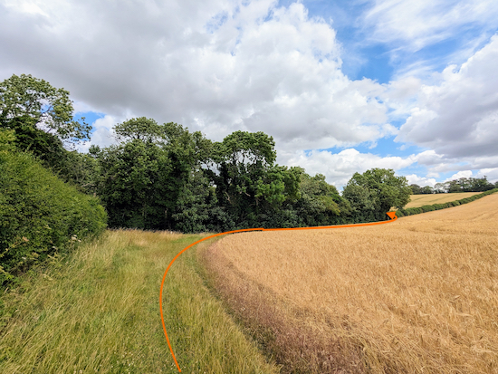 |
| Follow Hexton footpath 2 around the edge of the field |
13: After cutting through the hedgerow continue heading NNE on Hexton footpath 2 for 460m, with the hedgerow on the left and field on the right, until the path cuts through woodland (location -
https://w3w.co/strut.arrow.snail), see image below.
 |
| Continue on Hexton footpath 2 until you reach a junction |
14: Continue on Hexton footpath 2, now heading NNW, for 435m until you reach a junction with a gravel track (location -
https://w3w.co/sides.spend.gloves), see image below.
 |
| Keep right at the junction then continue following Hexton footpath 2 |
15: Keep right at the junction then continue following Hexton footpath 2, now heading NNE, for 380m until you reach Hexton Road (location -
https://w3w.co/sideburns.symphonic.precluded).
16: Turn left on Hexton Road then head N for 180m to a road junction (location -
https://w3w.co/carting.jumbo.petition) see image below.
There isn't a pedestrian pavement along this stretch so please use the verge if needed.
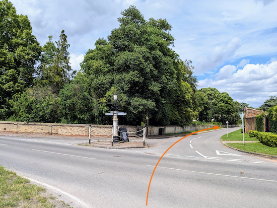 |
| Cross the junction then head N back to the starting point |
Cross the junction then continue heading straight and N for 400m back to The Raven and the starting point.
Interactive map


No comments:
Post a Comment