5.3 miles (8.5 km) with 135m of total ascent
 |
| The lane between points 2 & 3 |
This is a lovely station-to-station linear walk which starts and Watton-at-Stone Station then heads south-west via Brickground Wood and Tewin Wood before dropping down to Welwyn North Station. It is one of 15 linear walks on the site which have been created for those who prefer to leave the car at home and travel by public transport.
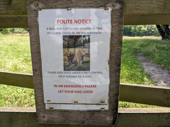
The White Horse at Burnham Green is a 380m detour about two-thirds of a way along the walk. You will cross one livestock field where there are signs asking dog owners to keep their pets on the lead.
Travel tip: The two stations,
Watton-at-Stone and
Welwyn North, are not on the same line; you will need to change at
Stevenage. We bought return tickets to Watton-at-Stone from our local station because it's cheaper than buying single tickets. On the way out we changed at
Welwyn Garden City then Stevenage. On the way back we changed at
Hatfield.
Fly through preview of walk
If you want to check what sort of landscape you will be crossing before you set off on this walk you can view a 30-second video (below) of the route. It includes a short detour to The White Horse where we stopped for lunch. The video is created using the free version of
Relive.
Directions
 |
Map for Walk 232: Watton-at-Stone to Welwyn North Linear
Click on the map above for a larger version
Created on Map Hub by Hertfordshire Walker
Elements © Thunderforest © OpenStreetMap contributors
There is an interactive map below these directions |
Those with GPS devices can download
GPX or
KML files for this walk. We've added
What3Words location references for those who use that system. If you print these walks you might want to use the green
PrintFriendly icon at the bottom of these directions to delete elements such as photographs.
 |
| Turn right on Station Road then head SW over the railway bridge |
1: Exit Watton-at-Stone Station (location -
https://w3w.co/bleak.sweep.neon), turn right on Station Road then head SW over the railway bridge for 40m until you reach Church Lane on the left (location -
https://w3w.co/plates.legend.hers), see image below.
 |
| Turn left on Church Lane then head SSE |
Turn left on Church Lane then head SSE, with the railway on your left, for 260m until you reach a bend (location -
https://w3w.co/moss.ozone.settle), see image below.
 |
| When you reach a bend, turn right on a lane |
2: When you reach a bend, turn right on a lane which is also Watton-at-Stone
bridleway 22.
The bridleway sign had been bent when we tested the route and it pointed into a field. Do not enter the field. The sign should be pointing along the metalled lane. Head SW down the lane for 740m until you reach Watkin's Hall Farm (location -
https://w3w.co/gear.dads.nature), see image below.
 |
| Turn left at Watkin's Hall Farm, still on Watton-at-Stone bridleway 22 |
3: Turn left at Watkin's Hall Farm, still on Watton-at-Stone bridleway 22, then head SW for 165m to a junction (location -
https://w3w.co/nests.across.helps), see image below.
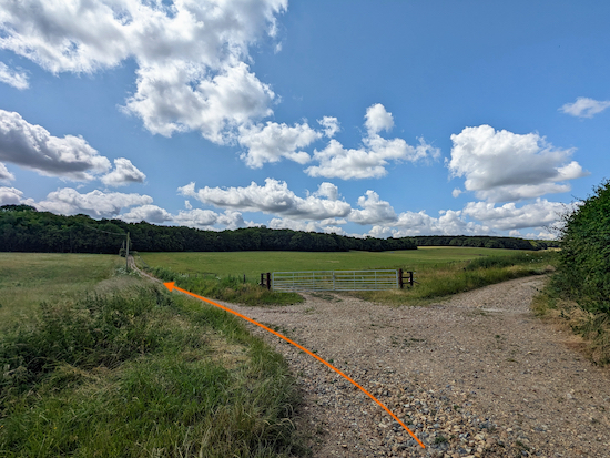 |
| Keep left at the junction then head SSE on Watton-at-Stone bridleway 35 |
4: Keep left at the junction then head SSE on Watton-at-Stone bridleway 35 for 250m, following it as it cuts through woodland and reaches a junction (location -
https://w3w.co/hears.curry.whites), see image below.
 |
| Turn right at the junction then head SW on Watton-at-Stone BOAT 29 |
5: Turn right at the junction then head SW on Watton-at-Stone BOAT 29 (
byway open to all traffic). Follow this byway for 870m, with wide-open views to the left and behind. Continue until you reach a junction (location -
https://w3w.co/woes.pulse.rise), see image below.
 |
| Keep right at the junction and follow the byway through shaded woodland |
6: Keep right at the junction, still on Watton-at-Stone BOAT 29, then follow the byway through a lovely stretch of shaded woodland. Continue heading SW then S for 745m until you reach a junction (location -
https://w3w.co/brush.bricks.packet), see image below.
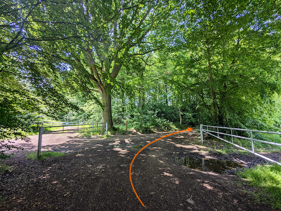 |
| Turn right at the junction, still on Watton-at-Stone BOAT 29 |
7: Turn right at the junction, still on Watton-at-Stone BOAT 29, then head SW for 120m until you reach another junction (location -
https://w3w.co/venue.voting.stud), see image below.
 |
| Continue straight across the junction, now on Bramfield bridleway 1 |
Continue straight across the junction, now on Bramfield bridleway 1, then head SW for 475m. There is a perfectly placed bench on the left as you walk this stretch. Ideal if you need a break. Continue until you reach a lane called Winding Shott (location -
https://w3w.co/indoor.chop.wins), see image below.
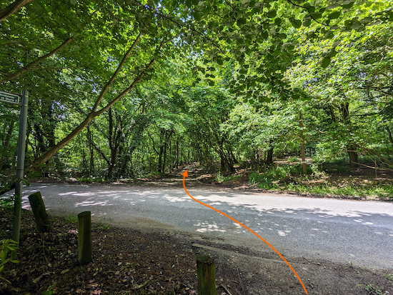 |
| Cross Winding Shott then head SW on a lane called Tewin Hill |
8: Cross Winding Shott then continue heading SW, now on a lane called Tewin Hill. Continue for 120m until you reach a
footpath on the right (location -
https://w3w.co/social.skinny.leaps), see image below.
 |
| Turn right on Tewin footpath 30 |
9: Turn right on Tewin footpath 30 then follow it W and uphill for 45m until you reach a junction (location -
https://w3w.co/assets.from.jolly), see image below.
 |
| Keep heading W, straight and slightly uphill at the junction |
Keep heading W, straight and slightly uphill at the junction (see orange arrow on the photograph above) then follow Tewin footpath 30 through a wonderful conifer woodland called Brickground Wood.
 |
| Tewin footpath 30 heading W through Brickground Wood |
 |
| Brickground Wood |
Continue through the woodland for 240m until you reach a junction (location -
https://w3w.co/tasty.pink.leans) see image below.
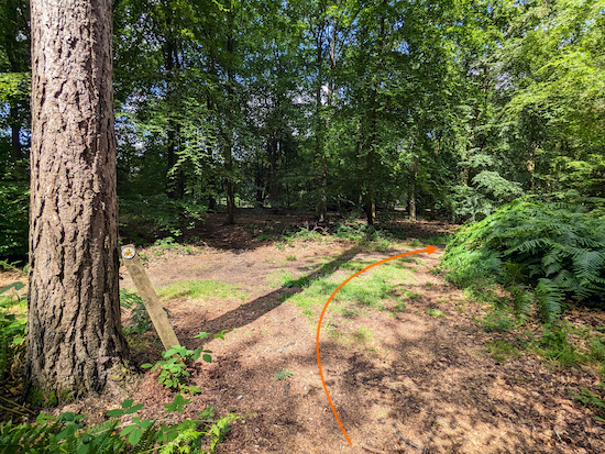 |
| Turn right at the junction, still on Tewin footpath 30 |
10: Turn right at the junction, still on Tewin footpath 30, then head N for 25m to another junction (location -
https://w3w.co/causes.cooks.behave), see image below.
 |
| Turn left at the junction, still on Tewin footpath 30 |
Turn left at the junction, still on Tewin footpath 30, then head W for 35m until you reach Queen Hoo Lane (location -
https://w3w.co/answer.beast.defend), see image below.
 |
| Cross Queen Hoo Lane then take the footpath on the other side |
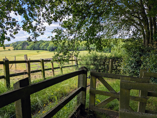
Cross Queen Hoo Lane then take the footpath on the other side, still Tewin footpath 30, then head WSW for 200m until the footpath bends right (location -
https://w3w.co/shaped.decide.spends), see image below.
 |
| Tewin footpath 30 now heads NNW, W, then NW |
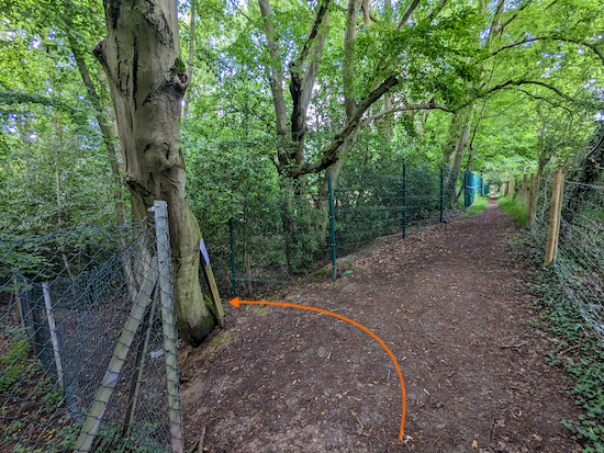
11: Tewin footpath 30 now heads NNW then W then NW for 330m.
This section was slightly overgrown when we tested this walk in June 2023 but not bad enough to block the way. Probably worth picking up a stick to push back any nettles and brambles. Continue until you reach a footpath junction (location -
https://w3w.co/flames.waddle.gone), see image below.
 |
| Turn left at the junction, still on Tewin footpath 30 |
Turn left at the junction then head WSW, still on Tewin footpath 30, for 15m to another junction (location -
https://w3w.co/fetch.nail.grants), see image below.
 |
| Tewin footpath 30 now bends right then heads WNW |
Tewin footpath 30 now bends right then heads WNW for 90m between green chain-linked fences until it reaches Firs Walk (location -
https://w3w.co/dollar.aims.raced), see image below.
 |
| Continue heading WNW along Firs Walk, still on Tewin footpath 30 |
Continue heading WNW along Firs Walk, still on Tewin footpath 30, for 120m until you reach Bishop's Road (location -
https://w3w.co/zebra.logs.insist), see image below.
 |
| Cross Bishop's Road, still on Tewin footpath 30 |
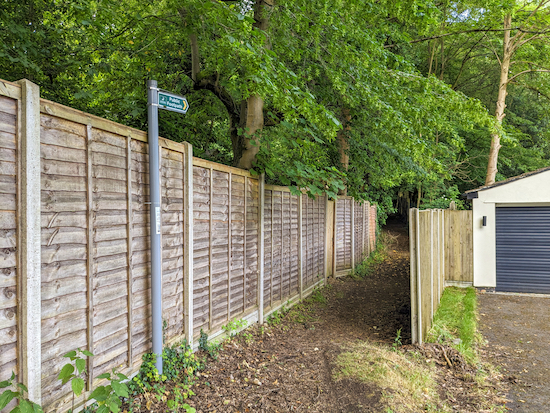
13: Cross Bishop's Road, still on Tewin footpath 30, then head WSW for 150m until the footpath crosses a drive and continues to the left of a garage (location -
https://w3w.co/scar.fingernails.became), see image below.
 |
| Continue heading WSW on Tewin footpath 30 |
Continue heading WSW on Tewin footpath 30 for 100m until you reach a footpath junction (location -
https://w3w.co/most.tennis.monks) see image below.
 |
| Continue heading WSW on Tewin footpath 30 |
14: Continue heading WSW on Tewin footpath 30 for 340m until you reach Tewin Close (location -
https://w3w.co/react.prop.stops).
 |
| Continue along Tewin Close, now heading SW |
Continue along Tewin Close, heading SW on Tewin footpath 30, for 60m to a junction (location -
https://w3w.co/attend.clear.washed) where you turn right then head W for 120m until you reach Orchard Road (location -
https://w3w.co/local.glaze.speeds).
* When you reach Orchard Road you have the option of turning right then heading NW for 380m to Burnham Green and The White Horse pub/restaurant (location - https://w3w.co/brass.dairy.purely). This detour will increase the total distance walked to 5.5 miles.
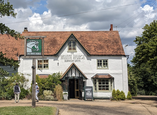 |
| The White Horse at Burnham Green, a short detour from the route |
 |
| Cross Orchard Road then take Tewin footpath 12 |
15: If you don't take the detour to The White Horse, cross Orchard Road then take Tewin footpath 12 which you follow SW for 85m to a gate (location -
https://w3w.co/basic.newly.that), see image below.
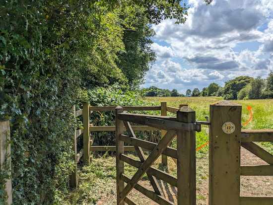 |
| Take the right fork after the gate then head SW on Tewin footpath 12 |
Take the right fork after the gate then head SW on Tewin footpath 12, see image below.
 |
| Take the right fork after the gate, Tewin footpath 12 |
Continue on Tewin footpath 12 for 65m at which point the footpath you are on becomes Welwyn footpath 35. Continue heading SW, with the hedgerow on the right and the field on the left, for 190m to a gate leading to a livestock field (location -
https://w3w.co/person.bikes.agent), see image below.
 |
| The sign on the gate leading to the livestock field |
16: Go through the gate then continue heading SW on Welwyn footpath 35, with the hedgerow on the right and the field on the left, for 310m to a gate (location -
https://w3w.co/couches.held.ports), see image below.
 |
| Go through the gate then continue heading SW, still on Welwyn footpath 35 |
17: Go through the gate then continue heading SW, still on Welwyn footpath 35, with the woodland on the right and field on the left.
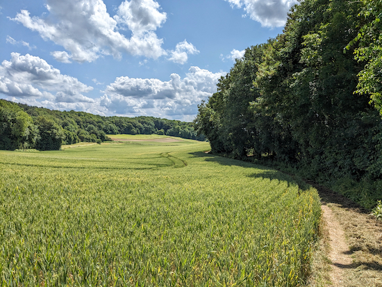 |
| Continue for 120m until you reach the end of the woodland |
Continue for 120m until you reach the end of the woodland and the point where the footpath crosses an arable field (location -
https://w3w.co/dock.relay.sunk), see image below.
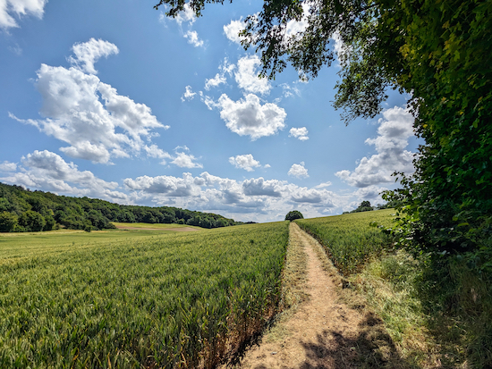 |
| Cross the arable field, still heading SW and still on Welwyn footpath 35 |
Cross the arable field, still heading SW and still on Welwyn footpath 35. This is a lovely stretch with some great views. Continue for 230m until you reach a junction (location -
https://w3w.co/jars.jazzy.bless), see image below.
 |
| Cross the junction then continue heading SW, still on Welwyn footpath 35 |
18: Cross the junction then continue heading SW, still on Welwyn footpath 35, with the hedgerow on the right and field on the left. This is another lovely section of the walk.
 |
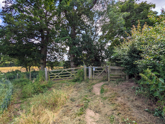
| Continue along Welwyn footpath 35 for 670m to a T-junction |
Continue for 670m to a T-junction (location -
https://w3w.co/maker.vine.asking), see image below.
 |
| Turn right on Welwyn bridleway 37 then head WNW |
19: Turn right on Welwyn bridleway 37 then head WNW then W for 785m to Harmer Green Lane (location -
https://w3w.co/stand.glow.slurs)..
20: Turn right on Harmer Green Lane then head N for 370m until you reach Adele Avenue on the left (location -
https://w3w.co/uses.people.locker). There is a shorter route to the station up Harmer Green Lane, but it involves walking in the road because there is no pedestrian pavement. The route we have chosen is a little longer, but safer. See the map below.
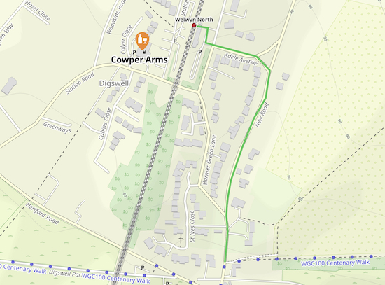 |
| The route from Welwyn bridleway 37 to the station |
21: Turn left on Adele Avenue then head W for 100m to reach Welwyn North Station (location -
https://w3w.co/twig.lock.heats)
* There is a cafe at the station, The Deli Stop, which closes at 2pm. There is a shop on the right as you approach the station. And The Cowper Arms is on the other side of the tracks as you approach the station (location - https://w3w.co/filled.yard.dining).
Interactive map


No comments:
Post a Comment