6.8 miles (11km) with 112m of total ascent
 |
Directions
 |
| Map for Walk 134: Ferneux Pelham West Loop Created on Map Hub by Hertfordshire Walker Elements © Thunderforest © OpenStreetMap contributors There is an interactive map below these directions |
1: From The Street in Furneux Pelham (location - https://w3w.co/worm.crackling.coffee) head S along The Causeway for 70m looking out for a footpath on the right (location - https://w3w.co/projects.bugs.chainsaw).
Take this path, Furneux Pelham footpath 8, and head WSW for 40m until you reach a gate and a footpath junction. Go through the gate and turn left heading S on Furneux Pelham footpath 7 for 120m with the hedgerow on your left and the field on your right until you reach a gap in the hedge (location - https://w3w.co/intestine.line.mops).
Once through the gap in the hedge head SW diagonally to your right for 210m to another gap in the hedge. (location - https://w3w.co/suddenly.inhaler.disprove).
Continue heading SW then S for 400m until you reach Patient End (location - https://w3w.co/student.consoled.logbook).
* When we did this walk the path hadn't been reinstated after the sowing of the crop so we walked around the edge of the field with the hedgerow on the right and the field on the left until we reached Patient End, see slight detour marked in red on the map below.
 |
| The short detour along the edge of the field to avoid trampling on the crop |
 |
| The bridleway goes to the left of the hedgerow and heads WSW |
3: Turn right on Braughing bridleway 8 and head NW for 90m before taking Braughing bridleway 14 on your left (location - https://w3w.co/knee.capillary.resting).
Head WSW on this bridleway climbing the hill with the hedgerow on the left and field on the right until you reach a junction (location - https://w3w.co/emperor.juicy.quirky), see image below.
 |
| At the junction keep to your right and walk in the direction of the telegraph poles |
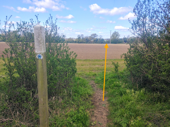
Head W across the field for 220m heading to the left of the telegraph pole and aiming for a gap in the hedgerow to the right of a building with a green roof (location - https://w3w.co/garage.startles.strutting), see image below with yellow direction arrow.
 |
| Head to the left of the telegraph pole |
Follow this bridleway WSW for 240m until you reach a house on the right (location - https://w3w.co/pushy.flying.chromatic). Continue heading WSW for 490m until you reach a bridleway junction (location - https://w3w.co/bullion.jugs.adapt).
5: Turn right on Braughing bridleway 12 and head N for 180m to a left turn (location - https://w3w.co/corporate.charge.kneeled). Turn left on Braughing bridleway 3 and head WNW for 90m to another junction (location - https://w3w.co/ally.risky.surcharge).
* At this point you will be following parts of the Greenwich Meridian Trail (GMT) and the rights of way may not be numbered but, instead, might have GMT stickers on them.
6: Turn right on Braughing restricted bridleway 24 then head NNW then NW for 230m until you reach a gap in the hedgerow just before woodland (location - https://w3w.co/chain.sidelined.inefficient).
Turn right here and continue heading NNW then N for 530m first with the woodland on your left before reaching a clearing..
Continuing along the track with the hedgerow on your left and the field on your right. After a dip the track eventually becomes Hormead footpath 16 which you continue to follow passing through Mumfords Farm (location - https://w3w.co/playful.tame.acoustics), see image of route through the farmyard below. The track, at this point, is also The Hertfordshire Way and the Greenwich Meridian Trail.
 |
| The route through Mumfords Farm |
 |
| Turn right just before you reach the wooden steps |
 |
| Turn left at the junction and then take a right turn |
* When we did this walk the path across the crop had not been reinstated so we kept to the right and walked round the edge of the field with the hedgerow on our right and the field on the left until we met Hormead footpath 28 on the other side of the field (location - https://w3w.co/tennis.mows.reservoir).
Continue on Hormead footpath 28 and head ENE then NE for 620m until you reach Duck Street (location - https://w3w.co/clasping.sentences.estate).
8: Cross Duck Street then take Hormead footpath 18 heading N. After 380m this path bends left around the perimeter of the field (location - https://w3w.co/spans.backdrop.crusher) then bends right and continues heading N for 210m until it reaches a junction (location - https://w3w.co/envisage.musical.handyman).
9: Turn right on Hormead restricted byway 20 and head ESE for 1.6km until you go through Great Hormead Park Wood.
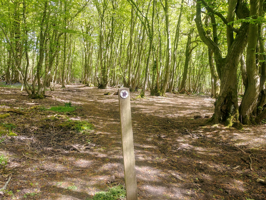
When you come to a fork in Hormead Park Wood (location - https://w3w.co/keen.waltz.spellings) take the right fork and continue until you reach the eastern edge of the woodland (location - https://w3w.co/munch.blurs.silently), see image below.
 |
| Take the right fork and head E through the woodland |
Turn right on Furneux Pelham footpath 1 and head SE for 570m, first with the hedgerow on your right and the field on your left, before crossing a field. Head SSE across the field to the right of a bush (location - https://w3w.co/touches.cavalier.vegetable), see image below. Continue across this field until you reach a gate leading to a farm track.
 |
| Keep to the right of the bush and head SE to a wooden gate |
Turn right here and head S for 80m with the hedgerow on your right and the field on your left until you reach the end of the hedgerow and a permissive path sign on your right (location - https://w3w.co/sedative.alleges.stays).
Cross the field heading S for 250m until you reach a footpath junction (location - https://w3w.co/polka.dugouts.screaming).
* When we did this walk the farmer was spraying slurry and suggested we keep to the edge of the field to avoid getting it on our boots. The detour he sent us on is marked in blue on the map below.
 |
| The detour along the edge of the field just after point 11 |
* The day we walked this route there were curious young bullocks in this field. They were fine, but, if you are worried about livestock you could take an alternative route by heading S on Furneux Pelham footpath 2 for 650m then turning left on The Street for 520m until you reach the start point (see detour option below).
 |
| The orange line shows the detour if you are afraid of livestock |
Another lovely walk, with some big skies and variety of environment. The usual summer overgrowth in places, but nothing completely unnavigable. Thanks for putting it up here!
ReplyDeleteHi Steve,
DeleteGlad you enjoyed it. A lovely walk. Yes, the summer surge in nettle and bramble growth is a problem this time of the year. I carry a stick to push them back with and secateurs to trim the worst.
Thanks for the feedback.
David
Did this walk this week though cut the corner at point 7 as always like to include the Hertfordshire Way into a walk! It was great, took about 2.5 hours at a brisk pace, very very muddy though and boots got very clogged. Great fun!
ReplyDeleteExcellent, glad you enjoyed it. The mud is a challenge this time of the year, but all part of the experience.
Delete